IMAGES TAKEN NEAR TO
Speen Road, HIGH WYCOMBE, HP14 4NN
Introduction
This page details the photographs taken nearby to Speen Road, HP14 4NN by members of the Geograph project.
The Geograph project started in 2005 with the aim of publishing, organising and preserving representative images for every square kilometre of Great Britain, Ireland and the Isle of Man.

There are currently over 7.5m images from over14,400 individuals and you can help contribute to the project by visiting https://www.geograph.org.uk
Image Map (Loading...)


Getting Data...Please wait
Leaflet Map data © OpenStreetMap
Images are licensed for reuse under creativecommons.org/licenses/by-sa/2.0
Notes
- Clicking on the map will re-center to the selected point.
- The higher the marker number, the further away the image location is from the centre of the postcode.
Image Listing (2 Images Found)
Images are licensed for reuse under creativecommons.org/licenses/by-sa/2.0
Image
Details
Distance
1
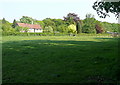
Towards Little Piggotts
The house is on a broad ridge, one of many, and although the land looks flat it drops behind us and again immediately beyond the house. The area is characterised by pastures interspersed with woodland.
Image: © Graham Horn
Taken: 30 Apr 2011
0.22 miles
2
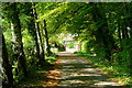
Towards Little Piggotts
This is the drive to a secluded property. It is also a popular walk, one of many in the area. Although we are on one of the Chiltern ridges this is not noticeable because of the surrounding woodland.
Image: © Graham Horn
Taken: 30 Apr 2011
0.23 miles