IMAGES TAKEN NEAR TO
Piggotts Hill, HIGH WYCOMBE, HP14 4NF
Introduction
This page details the photographs taken nearby to Piggotts Hill, HP14 4NF by members of the Geograph project.
The Geograph project started in 2005 with the aim of publishing, organising and preserving representative images for every square kilometre of Great Britain, Ireland and the Isle of Man.

There are currently over 7.5m images from over14,400 individuals and you can help contribute to the project by visiting https://www.geograph.org.uk
Image Map
Images are licensed for reuse under creativecommons.org/licenses/by-sa/2.0
Notes
- Clicking on the map will re-center to the selected point.
- The higher the marker number, the further away the image location is from the centre of the postcode.
Image Listing (5 Images Found)
Images are licensed for reuse under creativecommons.org/licenses/by-sa/2.0
Image
Details
Distance
1
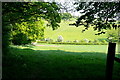
View from Piggott's Wood
This part of the Chilterns consists of alternate ridges and valleys, with lots of woodland interspersed with meadows. Here the footpath emerges from a wood, and can be seen dropping to the lane in the valley before rising to the next ridge.
Image: © Graham Horn
Taken: 30 Apr 2011
0.21 miles
2
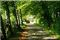
Towards Little Piggotts
This is the drive to a secluded property. It is also a popular walk, one of many in the area. Although we are on one of the Chiltern ridges this is not noticeable because of the surrounding woodland.
Image: © Graham Horn
Taken: 30 Apr 2011
0.21 miles
3
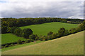
The valley of Bryant's Bottom
A view across to Piggott's Wood from the footpath below New House Farm.
Image: © Andrew Smith
Taken: 17 Aug 2008
0.21 miles
5
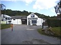
Beechdean Dairy Farm, Upper North Dean
Their main product is ice cream
Image: © David Howard
Taken: 10 Aug 2017
0.24 miles