IMAGES TAKEN NEAR TO
Valley Road, HIGH WYCOMBE, HP14 4LW
Introduction
This page details the photographs taken nearby to Valley Road, HP14 4LW by members of the Geograph project.
The Geograph project started in 2005 with the aim of publishing, organising and preserving representative images for every square kilometre of Great Britain, Ireland and the Isle of Man.

There are currently over 7.5m images from over14,400 individuals and you can help contribute to the project by visiting https://www.geograph.org.uk
Image Map
Images are licensed for reuse under creativecommons.org/licenses/by-sa/2.0
Notes
- Clicking on the map will re-center to the selected point.
- The higher the marker number, the further away the image location is from the centre of the postcode.
Image Listing (9 Images Found)
Images are licensed for reuse under creativecommons.org/licenses/by-sa/2.0
Image
Details
Distance
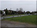
1
South Maundin, Hughenden Valley
Hughenden Valley isn't an old place. Most of the housing is mid 20th century.
South Maundin is an odd name for a road.
Image: © Des Blenkinsopp
Taken: 18 Sep 2019
0.03 miles
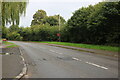
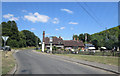
3
Warrendene Road at the junction of Speen Road
Image: © David Howard
Taken: 10 Aug 2017
0.12 miles
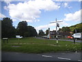
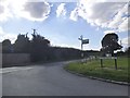
6
Warrendene Road
Warrendene Road at The Harrow Pub Hughenden Valley
Image: © Shaun Ferguson
Taken: 22 Mar 2008
0.14 miles
7
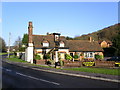
The Harrow Public House
The only pub in Hughenden Valley.
Image: © Ian Stewart
Taken: 26 Dec 2004
0.15 miles
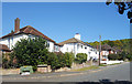
8
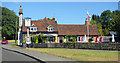
The Harrow, Hughenden Valley
A country pub at a road junction at the north end of Hughenden Valley village.
Image: © Des Blenkinsopp
Taken: 18 Sep 2019
0.15 miles