IMAGES TAKEN NEAR TO
Haw Lane, HIGH WYCOMBE, HP14 4JQ
Introduction
This page details the photographs taken nearby to Haw Lane, HP14 4JQ by members of the Geograph project.
The Geograph project started in 2005 with the aim of publishing, organising and preserving representative images for every square kilometre of Great Britain, Ireland and the Isle of Man.

There are currently over 7.5m images from over14,400 individuals and you can help contribute to the project by visiting https://www.geograph.org.uk
Image Map
Images are licensed for reuse under creativecommons.org/licenses/by-sa/2.0
Notes
- Clicking on the map will re-center to the selected point.
- The higher the marker number, the further away the image location is from the centre of the postcode.
Image Listing (10 Images Found)
Images are licensed for reuse under creativecommons.org/licenses/by-sa/2.0
Image
Details
Distance
1
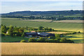
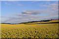
Lodge Hill Farm
A view from one of the footpaths descending from Bledlow Ridge. The steep grassland here gives way to arable land in the valley which cuts through the Chilterns between High Wycombe and Princes Risborough.
Image: © Andrew Smith
Taken: 13 Jul 2008
0.05 miles
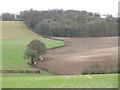
2

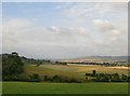
Lodge Hill Farm from Rout's Green
View from a pleasant footpath across fields just below Bledlow Ridge. See Image for another view of the farm and its surroundings.
Image: © David Hawgood
Taken: 17 Apr 2010
0.06 miles
3
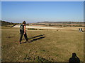
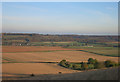
View from Bledlow Ridge on a day of sunshine and showers
Photo taken from the footpath which heads downhill from Chapel Lane. The view is a few degrees east of north. with Lodge Hill to the left in the middle distance, while Lodge Hill Farm is hidden among trees at the foot of the slope on the right. In the far distance is Pulpit Hill, and the Chiltern scarp towards Wendover.
Over Bledlow Ridge the light was changing from minute to minute. A few miles away the sun was shining on Saunderton and the Risboroughs (the Ercol factory shows as a white fleck) but in the far distance there is rain coming in over the Vale of Aylesbury.
Image: © Stefan Czapski
Taken: 26 Aug 2014
0.10 miles
5
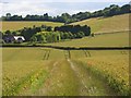
Farmland, Saunderton
Looking along the footpath leading to Lodge Hill Farm. Bledlow Ridge's grassland rises in the background.
Image: © Andrew Smith
Taken: 13 Jul 2008
0.14 miles
6
Farmland, Bledlow
Wheat in the valley between Lodge Hill and Bledlow Ridge.
Image: © Andrew Smith
Taken: 13 Jul 2008
0.17 miles
7
Chiltern View near Saunderton
Looking north east from Bledlow Ridge. The buildings centre left are in Saunderton Lee, the white line centre right is a train.
Image: © Des Blenkinsopp
Taken: 11 Nov 2016
0.17 miles
8
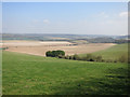
Chiltern View, Bledlow Ridge
Big views both north and south from the top of Bledlow Ridge and the numerous footpaths that descend from it.
Image: © Des Blenkinsopp
Taken: 7 Apr 2015
0.19 miles
9
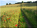
Farmland, Bledlow
A bridleway through wheat heading to the scarp on Bledlow Ridge.
Image: © Andrew Smith
Taken: 13 Jul 2008
0.21 miles
10
Fields and woods seen from a path leading to Lodge Hill
Image: © Peter S
Taken: 28 Dec 2011
0.22 miles