IMAGES TAKEN NEAR TO
Wycombe Road, HIGH WYCOMBE, HP14 4JB
Introduction
This page details the photographs taken nearby to Wycombe Road, HP14 4JB by members of the Geograph project.
The Geograph project started in 2005 with the aim of publishing, organising and preserving representative images for every square kilometre of Great Britain, Ireland and the Isle of Man.

There are currently over 7.5m images from over14,400 individuals and you can help contribute to the project by visiting https://www.geograph.org.uk
Image Map
Images are licensed for reuse under creativecommons.org/licenses/by-sa/2.0
Notes
- Clicking on the map will re-center to the selected point.
- The higher the marker number, the further away the image location is from the centre of the postcode.
Image Listing (3 Images Found)
Images are licensed for reuse under creativecommons.org/licenses/by-sa/2.0
Image
Details
Distance
1
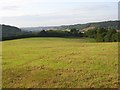
Farmland, Saunderton
A mown field above the valley leading towards Wycombe.
Image: © Andrew Smith
Taken: 1 Sep 2008
0.07 miles
2
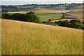
Pasture, Bradenham
The hillside above Munt's Wood with a view across to Bledlow Ridge.
Image: © Andrew Smith
Taken: 9 Jul 2023
0.21 miles
3
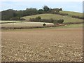
Farmland, Bradenham
Arable land in the Wycombe-Risborough valley with pasture on a hillside to the north of Smalldean Lane.
Image: © Andrew Smith
Taken: 3 Feb 2008
0.21 miles