IMAGES TAKEN NEAR TO
Bradenham Road, HIGH WYCOMBE, HP14 4EZ
Introduction
This page details the photographs taken nearby to Bradenham Road, HP14 4EZ by members of the Geograph project.
The Geograph project started in 2005 with the aim of publishing, organising and preserving representative images for every square kilometre of Great Britain, Ireland and the Isle of Man.

There are currently over 7.5m images from over14,400 individuals and you can help contribute to the project by visiting https://www.geograph.org.uk
Image Map
Images are licensed for reuse under creativecommons.org/licenses/by-sa/2.0
Notes
- Clicking on the map will re-center to the selected point.
- The higher the marker number, the further away the image location is from the centre of the postcode.
Image Listing (6 Images Found)
Images are licensed for reuse under creativecommons.org/licenses/by-sa/2.0
Image
Details
Distance
2
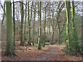
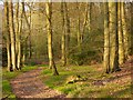
Pimlock's Wood, Bradenham
A permissive footpath heading down through beeches. This is part of the National Trust's estate at Bradenham.
Image: © Andrew Smith
Taken: 3 Feb 2008
0.13 miles
3
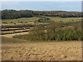
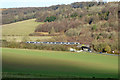
Meadow and woodland, West Wycombe
Looking down on the southern tip of Pimlock's Wood from beside Kit's Wood. Across the valley is the ridge to the north of West Wycombe Hill.
Image: © Andrew Smith
Taken: 3 Feb 2008
0.13 miles
5
Woodland, Bradenham
Beech trees in evening sunshine with a permitted path climbing from the A4010.
Image: © Andrew Smith
Taken: 14 Apr 2019
0.24 miles
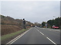
6
Northbound Chiltern Railways train north of West Wycombe
Climbing at 1 in 164 towards the line summit at Saunderton. The A4010 has just been crossed.
Image: © Robin Webster
Taken: 23 Nov 2017
0.24 miles