IMAGES TAKEN NEAR TO
Bradenham Road, HIGH WYCOMBE, HP14 4EY
Introduction
This page details the photographs taken nearby to Bradenham Road, HP14 4EY by members of the Geograph project.
The Geograph project started in 2005 with the aim of publishing, organising and preserving representative images for every square kilometre of Great Britain, Ireland and the Isle of Man.

There are currently over 7.5m images from over14,400 individuals and you can help contribute to the project by visiting https://www.geograph.org.uk
Image Map
Images are licensed for reuse under creativecommons.org/licenses/by-sa/2.0
Notes
- Clicking on the map will re-center to the selected point.
- The higher the marker number, the further away the image location is from the centre of the postcode.
Image Listing (12 Images Found)
Images are licensed for reuse under creativecommons.org/licenses/by-sa/2.0
Image
Details
Distance
2
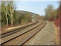
Northbound Chiltern Railways train north of West Wycombe
Climbing at 1 in 164 towards the line summit at Saunderton. The A4010 has just been crossed.
Image: © Robin Webster
Taken: 23 Nov 2017
0.11 miles
3
Railway bridge NAJ2/81
The Chiltern Line crosses the A4010. Signed as a low bridge, but this applies only to the sides of the arch. The central part has a road clearance signed as 16'-3" which should be safe for all usual traffic.
Image: © Robin Webster
Taken: 23 Nov 2017
0.15 miles
4

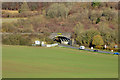
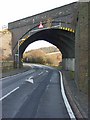
Railway bridge over the A4010
This brick built bridge carries the Chiltern Main Line over the A4010 road at West Wycombe on its way from High Wycombe to Princes Risborough. It was built in the early 1900's as a replacement for the old Wycombe Railway bridge. The Wycombe Railway was a single track formerly broad gauge railway between Maidenhead and Oxford. The line was rebuilt as part of the Great Western/Great Central Joint Railway built from Northolt to Banbury to cut journey times from Paddington to Birmingham. It also provided the Great Central with a second route from Marylebone to the north. Today's services run from Marylebone to Birmingham Snow Hill. The construction of the bridge is interesting in that it consists of 5 separate brick arches built on the skew across the road, clearly shown in the photograph. The abutments of the old bridge can be seen beyond the new one.
Image: © Bob Walters
Taken: 5 Mar 2022
0.16 miles
5
The railway, West Wycombe
Looking north along the Chiltern Line from the level crossing on the footpath below Great Cookshall Wood. In the middle distance, to the right of the track, you can see the parapet of the bridge over the A4010.
Image: © Andrew Smith
Taken: 3 Feb 2008
0.16 miles
7
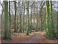
Pimlock's Wood, Bradenham
A permissive footpath heading down through beeches. This is part of the National Trust's estate at Bradenham.
Image: © Andrew Smith
Taken: 3 Feb 2008
0.22 miles
8
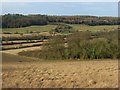
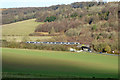
Meadow and woodland, West Wycombe
Looking down on the southern tip of Pimlock's Wood from beside Kit's Wood. Across the valley is the ridge to the north of West Wycombe Hill.
Image: © Andrew Smith
Taken: 3 Feb 2008
0.22 miles
9
Railway bridge, West Wycombe
The A4010 passing beneath the Chiltern Line. In the foreground is part of an older and lower bridge.
Image: © Andrew Smith
Taken: 3 Feb 2008
0.22 miles
10
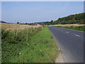
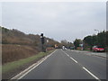
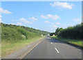
Bradenham Road
Bradenham Road (A4010) heading up to the railway bridge.
Image: © Shaun Ferguson
Taken: 20 Sep 2008
0.23 miles