IMAGES TAKEN NEAR TO
Horseshoe Road, HIGH WYCOMBE, HP14 4EB
Introduction
This page details the photographs taken nearby to Horseshoe Road, HP14 4EB by members of the Geograph project.
The Geograph project started in 2005 with the aim of publishing, organising and preserving representative images for every square kilometre of Great Britain, Ireland and the Isle of Man.

There are currently over 7.5m images from over14,400 individuals and you can help contribute to the project by visiting https://www.geograph.org.uk
Image Map
Images are licensed for reuse under creativecommons.org/licenses/by-sa/2.0
Notes
- Clicking on the map will re-center to the selected point.
- The higher the marker number, the further away the image location is from the centre of the postcode.
Image Listing (15 Images Found)
Images are licensed for reuse under creativecommons.org/licenses/by-sa/2.0
Image
Details
Distance
1
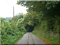
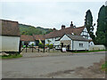
Horseshoe Road, Radnage
Further down the hill is a pub, The Three Horseshoes. Is the road named after the missing one?
Image: © Robin Webster
Taken: 18 Oct 2015
0.03 miles
3
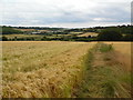
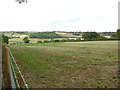
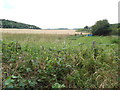
View above Bennett End
Taken in a field full of barley below Andridge Farm, this view is looking south east towards The City and the surrounding Chiltern Hills.
Image: © David Hillas
Taken: 30 Jul 2016
0.08 miles
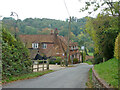
5
Bennett End Farm, Radnage
The house is a grade II listed building, oldest parts 17th century.
Image: © Robin Webster
Taken: 18 Oct 2015
0.15 miles
6
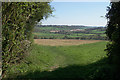
View from The City towards Radnage (1)
This photo shows typical Chiltern hill country looking northwards towards Radnage from the path just North of The City. This path goes down towards Bennett End.
Image: © David Hillas
Taken: 30 Jul 2016
0.17 miles
7
Footpath leaving Andridge
Part of the Chiltern Way. The church on West Wycombe Hill can be seen from here.
Image: © Bill Boaden
Taken: 20 Apr 2018
0.17 miles
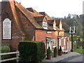
8
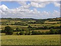
Countryside, Radnage
Radnage is scattered across this dry valley and up the hill to the right. Small fields of pasture occupy much of the valley bottom.
Image: © Andrew Smith
Taken: 5 Jul 2008
0.18 miles
9
View looking West from Bennett End
This photo shows fields looking West from the path just South of Bennett End. Pophley's Wood can be seen to the left of the photo.
Image: © David Hillas
Taken: 30 Jul 2016
0.18 miles
10
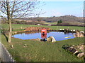
Phonebox in pub garden
Here's a shot of a rather interesting phone box in the heart of the Chilterns. The pond is in the back garden of the Three Horseshoes pub at Bennett End. At night the box is often lit (with its original internal lights). The surrounding countryside is very popular with Red Kite spotters.
Image: © Nick Powell
Taken: Unknown
0.19 miles