IMAGES TAKEN NEAR TO
Green Lane, HIGH WYCOMBE, HP14 4DJ
Introduction
This page details the photographs taken nearby to Green Lane, HP14 4DJ by members of the Geograph project.
The Geograph project started in 2005 with the aim of publishing, organising and preserving representative images for every square kilometre of Great Britain, Ireland and the Isle of Man.

There are currently over 7.5m images from over14,400 individuals and you can help contribute to the project by visiting https://www.geograph.org.uk
Image Map (Loading...)


Getting Data...Please wait
Leaflet Map data © OpenStreetMap
Images are licensed for reuse under creativecommons.org/licenses/by-sa/2.0
Notes
- Clicking on the map will re-center to the selected point.
- The higher the marker number, the further away the image location is from the centre of the postcode.
Image Listing (13 Images Found)
Images are licensed for reuse under creativecommons.org/licenses/by-sa/2.0
Image
Details
Distance
1

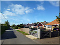
Green Lane, Radnage
A private road of post-war homes, mostly bungalows.
Image: © Andrew Smith
Taken: 11 Oct 2008
0.01 miles
4
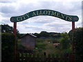
City Allotments Sign
This sign to the local allotments is located in Green Lane, The City, HP14 4DJ.
Image: © David Hillas
Taken: 24 Jul 2010
0.15 miles
7
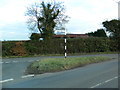
Junction of Green End Lane and Bowers Lane, The City,Radnage
Image: © John Lord
Taken: 24 Feb 2012
0.22 miles
8
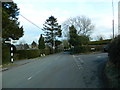
Junction of City Rd and Green End Rd, The City, Radnage
Image: © John Lord
Taken: 24 Feb 2012
0.23 miles
9
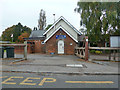
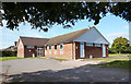
Radnage Church of England Primary School
The older part - a more modern part is off to the right.
Image: © Robin Webster
Taken: 18 Oct 2015
0.23 miles
10
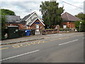
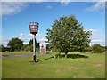
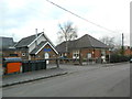
Radnage Church of England Primary School
Situated in City Road HP14 4DW, this school takes local children from Reception Class to Year 6. To the left of the photo can be seen a BT fibre-optic cabinet box ,whilst towards the right is a bus stop. At one time, Thames Valley bus route 40 then Wycombe Bus route 340 served Radnage, but these routes were withdrawn somewhile ago, hence no timetables are now shown on the bus stop.
Image: © David Hillas
Taken: 30 Jul 2016
0.23 miles