IMAGES TAKEN NEAR TO
The City, Chinnor Road, HIGH WYCOMBE, HP14 4AB
Introduction
This page details the photographs taken nearby to The City, Chinnor Road, HP14 4AB by members of the Geograph project.
The Geograph project started in 2005 with the aim of publishing, organising and preserving representative images for every square kilometre of Great Britain, Ireland and the Isle of Man.

There are currently over 7.5m images from over14,400 individuals and you can help contribute to the project by visiting https://www.geograph.org.uk
Image Map (Loading...)


Getting Data...Please wait
Leaflet Map data © OpenStreetMap
Images are licensed for reuse under creativecommons.org/licenses/by-sa/2.0
Notes
- Clicking on the map will re-center to the selected point.
- The higher the marker number, the further away the image location is from the centre of the postcode.
Image Listing (11 Images Found)
Images are licensed for reuse under creativecommons.org/licenses/by-sa/2.0
Image
Details
Distance
1
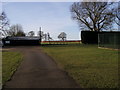
Bledlow Ridge Cricket Club
Bledlow Ridge Cricket Club off Chinnor Road
Image: © Shaun Ferguson
Taken: 25 Feb 2008
0.12 miles
2
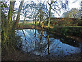
Pond, Bledlow Ridge
Such ponds in the highest parts of the Chilterns owe their existence to a thin layer of Clay with Flints that caps the permeable chalk.
Image: © David Ellis
Taken: 31 Dec 2005
0.15 miles
4
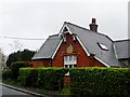
Old school house, Bledlow Ridge
The plaque on the gable reads "Bledlow School Board, 1874"
Image: © Bikeboy
Taken: 7 Apr 2014
0.17 miles
5
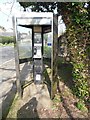
Former KX300 Telephone Kiosk in Bledlow Ridge
Situated in Chinnor Road, HP14 4AJ, this telephone kiosk has a BT notice on the right hand side indicating that the kiosk will shortly be removed due to lack of usage. The former BT Piper logo can just be seen on each side of the kiosk. Update: the telephone kiosk has since been removed from this location in Bledlow Ridge.
Image: © David Hillas
Taken: 7 Apr 2017
0.19 miles
6
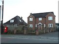
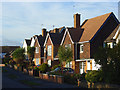
Bledlow Ridge village
Housing near corner of Chinnor Road and Haw Lane, typical of the housing boom here in the second half of the 20th Century.
Image: © David Ellis
Taken: 31 Dec 2005
0.19 miles
7
The Crest, Bledlow Ridge
A road running parallel to the main Chinnor Road which, like most of the village, consists of post-war houses.
Image: © Andrew Smith
Taken: 18 Oct 2008
0.19 miles
8
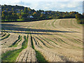
Farmland, Bledlow Ridge
This arable land occupies relatively flat land on the eastern side of the ridge below a strip of steeper grassland. The Haw Lane area of the village is in the background.
Image: © Andrew Smith
Taken: 18 Oct 2008
0.20 miles
9
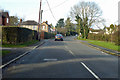
Chinnor Road through Bledlow Ridge
Towards Chinnor.
Image: © Robin Webster
Taken: 8 Dec 2019
0.20 miles
10
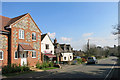
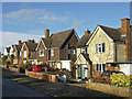
The Country Store, Bledlow Ridge
Village shop on Chinnor Road.
In the foreground is a new house with a decorative brick and flint frontage.
These were the traditional building materials round here for centuries. The style has been having a revival recently.
Image: © Des Blenkinsopp
Taken: 7 Apr 2015
0.23 miles