IMAGES TAKEN NEAR TO
Stokenchurch, HIGH WYCOMBE, HP14 3YN
Introduction
This page details the photographs taken nearby to HP14 3YN by members of the Geograph project.
The Geograph project started in 2005 with the aim of publishing, organising and preserving representative images for every square kilometre of Great Britain, Ireland and the Isle of Man.

There are currently over 7.5m images from over14,400 individuals and you can help contribute to the project by visiting https://www.geograph.org.uk
Image Map
Images are licensed for reuse under creativecommons.org/licenses/by-sa/2.0
Notes
- Clicking on the map will re-center to the selected point.
- The higher the marker number, the further away the image location is from the centre of the postcode.
Image Listing (29 Images Found)
Images are licensed for reuse under creativecommons.org/licenses/by-sa/2.0
Image
Details
Distance
1
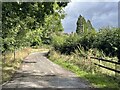
Entrance to Collier's Lane, Kingston Hill
The roof in the middle distance belongs to Parr's Common Cottages.
Image: © Simon Mortimer
Taken: 7 Sep 2022
0.04 miles
2
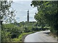
The top of Kingston Hill
Looking south towards Stokenchurch BT Tower.
Image: © Simon Mortimer
Taken: 7 Sep 2022
0.09 miles
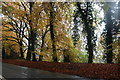
3
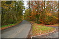
Towards Kingston Blount
This lane is well used by traffic from the B4009 making a diversion to avoid Watlington. Down Kingston Hill, just beyond that car, and you drop off the edge of the Chiltern scarp to Kingston Blount.
Image: © Graham Horn
Taken: 7 Nov 2010
0.10 miles
4
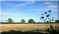
Hilltop Farmland
At around 240 metres AOD this is at the top of Kingston Hill, where the land levels out again after the steep and forested Chilterns escarpment.
Image: © Des Blenkinsopp
Taken: 19 Sep 2013
0.13 miles
5
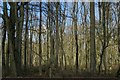
Grove Wood, from the layby at the top of Aston Hill
Image: © Christopher Hilton
Taken: 12 Apr 2008
0.14 miles
6

Paddock, Stokenchurch
The track leads from Gurdon's Farm to a cottage and the road at the top of Kingston Hill.
Image: © Andrew Smith
Taken: 11 Oct 2008
0.16 miles
7
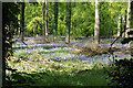
Bluebells in Grove Wood
The woodland covers the western side of the Chilterns, though all the bluebells seem to be at the top.
Image: © Bill Boaden
Taken: 10 May 2018
0.17 miles
8
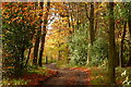
In Kingston Wood
A good bridleway follows the southern edge of Kingston Wood forming the boundary between Buckinghamshire (left) and Oxfordshire (right).
Image: © Graham Horn
Taken: 7 Nov 2010
0.17 miles
10

Farmland, Stokenchurch
Most of the fields around Gurdon's Farm are given over to horses. A ploughed field is to the left.
Image: © Andrew Smith
Taken: 11 Oct 2008
0.18 miles