IMAGES TAKEN NEAR TO
Cadmore End Common, HIGH WYCOMBE, HP14 3PT
Introduction
This page details the photographs taken nearby to Cadmore End Common, HP14 3PT by members of the Geograph project.
The Geograph project started in 2005 with the aim of publishing, organising and preserving representative images for every square kilometre of Great Britain, Ireland and the Isle of Man.

There are currently over 7.5m images from over14,400 individuals and you can help contribute to the project by visiting https://www.geograph.org.uk
Image Map
Images are licensed for reuse under creativecommons.org/licenses/by-sa/2.0
Notes
- Clicking on the map will re-center to the selected point.
- The higher the marker number, the further away the image location is from the centre of the postcode.
Image Listing (3 Images Found)
Images are licensed for reuse under creativecommons.org/licenses/by-sa/2.0
Image
Details
Distance
2
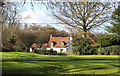
House on Cadmore End Common
Cadmore End Common is mostly woodland, but there are a number of isolated houses along the various tracks.
Image: © Des Blenkinsopp
Taken: 21 Nov 2015
0.18 miles
3
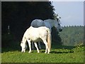
White horses, Watercroft Farm, Cadmore End
Horses graze in many of the smaller fields to the south of the farm in contrast to much of the area north and west which is mostly arable. An arrow on the post marks the route of the footpath heading in the direction of Leygrove's Wood, which can be seen in the background beyond a dry valley.
Image: © Andrew Smith
Taken: 27 Sep 2008
0.24 miles