IMAGES TAKEN NEAR TO
Chequers Lane, HIGH WYCOMBE, HP14 3PG
Introduction
This page details the photographs taken nearby to Chequers Lane, HP14 3PG by members of the Geograph project.
The Geograph project started in 2005 with the aim of publishing, organising and preserving representative images for every square kilometre of Great Britain, Ireland and the Isle of Man.

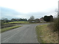
There are currently over 7.5m images from over14,400 individuals and you can help contribute to the project by visiting https://www.geograph.org.uk
Image Map
Images are licensed for reuse under creativecommons.org/licenses/by-sa/2.0
Notes
- Clicking on the map will re-center to the selected point.
- The higher the marker number, the further away the image location is from the centre of the postcode.
Image Listing (25 Images Found)
Images are licensed for reuse under creativecommons.org/licenses/by-sa/2.0
Image
Details
Distance
1
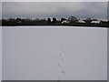
Snowy Footpath
Snowy Footpath heading to Chequers Lane
Image: © Shaun Ferguson
Taken: 7 Feb 2009
0.02 miles
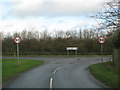
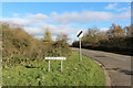
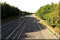
3
The B482, Marlow Road, at the junction with Bigmore Lane
Image: © John Lord
Taken: 24 Feb 2012
0.03 miles
4
Junction of Bigmore Lane and the B482, Marlow Road
Image: © John Lord
Taken: 24 Feb 2012
0.03 miles
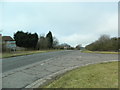
5
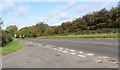
Bigmore Lane
A shortcut to the A40 via Bigmore Farm and Horsleys Green.
Image: © Des Blenkinsopp
Taken: 21 Nov 2015
0.04 miles
6
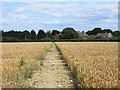
Farmland with footpath near Cadmore End
The path is passing through the final field of wheat before reaching the road near Chequers Manor.
Image: © Andrew Smith
Taken: 2 Aug 2009
0.04 miles
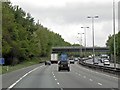
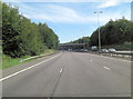
9
The M40 northbound from Bigmore Lane Bridge
Image: © Steve Daniels
Taken: 6 Oct 2013
0.08 miles