IMAGES TAKEN NEAR TO
Marlow Road, HIGH WYCOMBE, HP14 3NX
Introduction
This page details the photographs taken nearby to Marlow Road, HP14 3NX by members of the Geograph project.
The Geograph project started in 2005 with the aim of publishing, organising and preserving representative images for every square kilometre of Great Britain, Ireland and the Isle of Man.

There are currently over 7.5m images from over14,400 individuals and you can help contribute to the project by visiting https://www.geograph.org.uk
Image Map
Images are licensed for reuse under creativecommons.org/licenses/by-sa/2.0
Notes
- Clicking on the map will re-center to the selected point.
- The higher the marker number, the further away the image location is from the centre of the postcode.
Image Listing (10 Images Found)
Images are licensed for reuse under creativecommons.org/licenses/by-sa/2.0
Image
Details
Distance
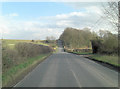
3
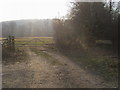
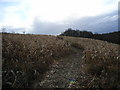
Footpath and bridleway
Footpath and bridleway by Pebbly Hill off Marlow Road
Image: © Shaun Ferguson
Taken: 29 Dec 2008
0.09 miles
4
Moor Wood
An area of conifers at the northern end of the wood. Rooftops at Pebbly Hill can just be seen through the trees. Widdenton Park Wood is in the distance.
Image: © Andrew Smith
Taken: 12 Apr 2008
0.12 miles
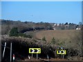
5
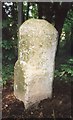
Old Milestone by the B482, west of Wycombe Air Park
Carved stone post by the B482, in parish of Lane End (Wycombe District), Marlow Road; Long Shaw Wood, North of Wycombe Airport, on tight hill bend beside footpath into open woodland, on East side of road. Marlow pillar, erected by the Gt Marlow & Stokenchurch turnpike trust in the 19th century.
Inscription once read:-
: (Stokenchurch / 5) : : (Marlow / 3) :
Carved benchmark lower front, part damaged.
Buckinghamshire HER.
HER Number: 1354400000 https://www.heritagegateway.org.uk/Gateway/Results_Single.aspx?uid=MBC25648&resourceID=1024
Milestone Society National ID: BU_MWST04
Image: © A Rosevear & J Higgins
Taken: 1 Aug 2002
0.12 miles
6
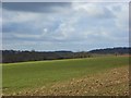
Farmland, Lane End
A cereal field beside Widedenton Park Wood. Looking towards the B482.
Image: © Andrew Smith
Taken: 12 Apr 2008
0.15 miles
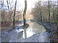
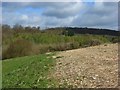
8
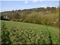
Moor Wood, Great Marlow
The steeper part of the slope is uncultivated, whereas above it is in arable production. A footpath descends to enter the wood to the right of picture.
Image: © Andrew Smith
Taken: 14 Apr 2019
0.23 miles