IMAGES TAKEN NEAR TO
Toweridge, HIGH WYCOMBE, HP14 3AT
Introduction
This page details the photographs taken nearby to Toweridge, HP14 3AT by members of the Geograph project.
The Geograph project started in 2005 with the aim of publishing, organising and preserving representative images for every square kilometre of Great Britain, Ireland and the Isle of Man.

There are currently over 7.5m images from over14,400 individuals and you can help contribute to the project by visiting https://www.geograph.org.uk
Image Map
Images are licensed for reuse under creativecommons.org/licenses/by-sa/2.0
Notes
- Clicking on the map will re-center to the selected point.
- The higher the marker number, the further away the image location is from the centre of the postcode.
Image Listing (9 Images Found)
Images are licensed for reuse under creativecommons.org/licenses/by-sa/2.0
Image
Details
Distance
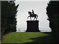
1
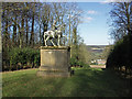
Statue, West Wycombe Park
I don’t know who the horseman is, possibly a member of the Dashwood family whose West Wycombe House can be seen in the background.
Image: © David Ellis
Taken: 9 Feb 2006
0.01 miles
2
West Wycombe Park
There is no inscription on the statue which is within the grounds of West Wycombe House seen behind the statue.
Image: © Peter Jemmett
Taken: 22 Jul 2007
0.01 miles
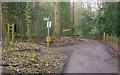
3
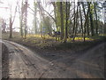
Toweridge Lane
Toweridge Lane at Towerage with footpaths to the South West and South East
Image: © Shaun Ferguson
Taken: 29 Dec 2008
0.01 miles
4
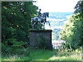
The Equestrian Statue in Wycombe Park
The equestrian statue of a Roman emperor is made of fibre glass and was purchased by the late Sir Francis Dashwood from Pinewood Studios for the price of a crate of champagne.
Image: © Steve Daniels
Taken: 11 Jun 2018
0.05 miles
5
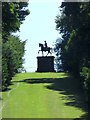
West Wycombe Park - Equestrian Statue
Sited on a hilltop at the end of a line of sight southwards from the mansion. This fibreglass statue of a mounted Roman emperor was bought from Pinewood Studios for a crate of champagne!
www.nationaltrust.org.uk
Image: © Colin Smith
Taken: 26 Jul 2022
0.05 miles
6
Towerridge Lane towards West Wycombe Village
Towerridge Lane is south and on the hill above West Wycombe House. The lane, directly ahead, leads downhill to the A40 at West Wycombe Village after half a mile. This is on the route of the London Green Belt Way.
Image: © Sean Davis
Taken: 13 Mar 2011
0.06 miles
7
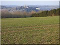
Farmland, West Wycombe
A view of the church and mausoleum from Towerage.
Image: © Andrew Smith
Taken: 18 Feb 2017
0.16 miles
8
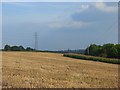
Farmland, Towerage
A field of stubble and maize above Hellbottom Wood. The spelling Towerage is used by the OS but Toweridge seems to be mainly used locally.
Image: © Andrew Smith
Taken: 21 Sep 2008
0.21 miles
9
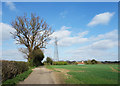
Track to Towerage Farm
Farm track and bridleway.
Image: © Des Blenkinsopp
Taken: 5 Apr 2017
0.23 miles