IMAGES TAKEN NEAR TO
Elm Green, HEMEL HEMPSTEAD, HP1 3PX
Introduction
This page details the photographs taken nearby to Elm Green, HP1 3PX by members of the Geograph project.
The Geograph project started in 2005 with the aim of publishing, organising and preserving representative images for every square kilometre of Great Britain, Ireland and the Isle of Man.

There are currently over 7.5m images from over14,400 individuals and you can help contribute to the project by visiting https://www.geograph.org.uk
Image Map (Loading...)


Getting Data...Please wait
Leaflet Map data © OpenStreetMap
Images are licensed for reuse under creativecommons.org/licenses/by-sa/2.0
Notes
- Clicking on the map will re-center to the selected point.
- The higher the marker number, the further away the image location is from the centre of the postcode.
Image Listing (8 Images Found)
Images are licensed for reuse under creativecommons.org/licenses/by-sa/2.0
Image
Details
Distance
1
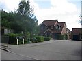
Houses in Polehanger Lane Gadebridge Hemel Hempstead
Polehanger Lane is at the extremity of the town
Image: © Jack Hill
Taken: 25 Aug 2005
0.13 miles
2
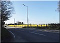
Rape field by Berkhamsted Road, Gadebridge
This is the border of the Hemel Hempstead urban area where the farmland begins.
Image: © David Howard
Taken: 23 Apr 2015
0.14 miles
3
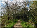
Path towards Polehanger Lane, Gadebridge
Image: © Bryn Holmes
Taken: 12 Apr 2021
0.18 miles
4
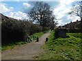
Path towards Polehanger Lane, Gadebridge
Image: © Bryn Holmes
Taken: 12 Apr 2021
0.19 miles
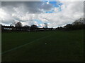
5

Fields End Lane
Heading away from Fields End towards suburban Hemel Hempstead.
Image: © Robin Webster
Taken: 7 Jan 2018
0.19 miles
6
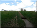
Steps towards Halsey Drive, Spring Fields
Image: © Bryn Holmes
Taken: 12 Apr 2021
0.21 miles
8
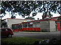
Martindale School, Warners End, Hemel Hempstead
The red panels are just a tad too bright perhaps?
Image: © Jack Hill
Taken: 25 Aug 2005
0.24 miles