IMAGES TAKEN NEAR TO
Long Arrotts, HEMEL HEMPSTEAD, HP1 3EY
Introduction
This page details the photographs taken nearby to Long Arrotts, HP1 3EY by members of the Geograph project.
The Geograph project started in 2005 with the aim of publishing, organising and preserving representative images for every square kilometre of Great Britain, Ireland and the Isle of Man.

There are currently over 7.5m images from over14,400 individuals and you can help contribute to the project by visiting https://www.geograph.org.uk
Image Map
Images are licensed for reuse under creativecommons.org/licenses/by-sa/2.0
Notes
- Clicking on the map will re-center to the selected point.
- The higher the marker number, the further away the image location is from the centre of the postcode.
Image Listing (9 Images Found)
Images are licensed for reuse under creativecommons.org/licenses/by-sa/2.0
Image
Details
Distance
1
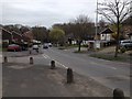
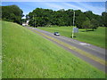
Galley Hill, Hemel Hempstead
Marlins Turn, where I happened to be delivering, is on the left.
Image: © John Winder
Taken: 13 Apr 2015
0.11 miles
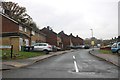
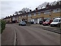
3
Hemel Hempstead: Gadebridge Estate
One of the blocks of housing at the eastern side of the Gadebridge Estate looking from Gadebridge Park.
Image: © Nigel Cox
Taken: 15 Jun 2006
0.13 miles
5
Hemel Hempstead: Galley Hill
Looking towards Gadebridge with Home Wood at the top of the hill.
Image: © Nigel Cox
Taken: 15 Jun 2006
0.15 miles
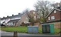
6
Marlins Turn, Hemel Hempstead
Following a recent BBC article on Geograph, I've taken the opportunity to upload some frankly rather dull shots of housing estates. ;-) As usual, I was here in a lorry delivering someone's roof, and I took this using the company iPhone during a break from unloading. I don't know where the name comes from, but the old OS map shows this whole area to be farmland and woods, with the intriguing legend "Roman Coins Found" emblazoned across it.
Image: © John Winder
Taken: 13 Apr 2015
0.19 miles
7

Leighton Buzzard Road, Piccotts End
Looking across Home Wood.
Image: © David Howard
Taken: 26 Nov 2022
0.19 miles
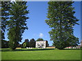
9
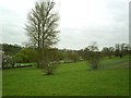
Gadebridge Park, looking towards Hemel Old Town
Gadebridge Park is formed from the grounds of Gadebridge House (now demolished), home of Sir Astley Paston Cooper, 1st Baronet (1768 – 1841), surgeon to King George IV.
The 200ft spire of St Mary's the parish church can be seen in the distance. The River Gade follows the line of willow trees in the middle distance.
Image: © Graham Hale
Taken: 5 Apr 2012
0.23 miles