IMAGES TAKEN NEAR TO
Roebuck Avenue, HIGH WYCOMBE, HP13 7TB
Introduction
This page details the photographs taken nearby to Roebuck Avenue, HP13 7TB by members of the Geograph project.
The Geograph project started in 2005 with the aim of publishing, organising and preserving representative images for every square kilometre of Great Britain, Ireland and the Isle of Man.

There are currently over 7.5m images from over14,400 individuals and you can help contribute to the project by visiting https://www.geograph.org.uk
Image Map (Loading...)


Getting Data...Please wait
Leaflet Map data © OpenStreetMap
Images are licensed for reuse under creativecommons.org/licenses/by-sa/2.0
Notes
- Clicking on the map will re-center to the selected point.
- The higher the marker number, the further away the image location is from the centre of the postcode.
Image Listing (11 Images Found)
Images are licensed for reuse under creativecommons.org/licenses/by-sa/2.0
Image
Details
Distance
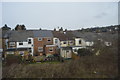
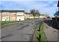
1
Towards the edge of town
Housing on the east side of High Wycombe.
Image: © Des Blenkinsopp
Taken: 4 Mar 2019
0.14 miles
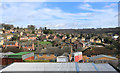
2
Micklefield, High Wycombe
Very little of High Wycombe is flat.
Image: © Des Blenkinsopp
Taken: 4 Mar 2019
0.16 miles
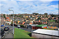
3
Hillside Housing
Houses on Micklefield Road, Horsenden Road, Roebuck Avenue and Hennerton Way, in ascending order.
Image: © Des Blenkinsopp
Taken: 4 Mar 2019
0.17 miles
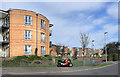
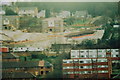
6
Bluebell Court Summer 1989
Taken of the development off Cock Lane from my bedroom window at the time in Kendalls Close. North end of development, other photos show southern end.
Image: © Tony White
Taken: 27 Oct 1989
0.23 miles
7

Bluebell Court Summer 1989
Taken of the development off Cock Lane from my bedroom window at the time in Kendalls Close. North end of development, other photo shows southern end http://www.geograph.org.uk/photo/2905064.
Image: © Tony White
Taken: 27 Aug 1989
0.23 miles
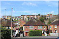
8
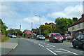
A steep part on Hatters Lane
High Wycombe is quite a hilly town.
Image: © Robin Webster
Taken: 9 Jun 2019
0.23 miles
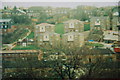
9
Bluebell Court Summer 1989
Taken of the development off Cock Lane from my bedroom window at the time in Kendalls Close. South end of development, other photos show northern end.
Image: © Tony White
Taken: 27 Oct 1989
0.23 miles