IMAGES TAKEN NEAR TO
Kingswood Place, HIGH WYCOMBE, HP13 7SR
Introduction
This page details the photographs taken nearby to Kingswood Place, HP13 7SR by members of the Geograph project.
The Geograph project started in 2005 with the aim of publishing, organising and preserving representative images for every square kilometre of Great Britain, Ireland and the Isle of Man.

There are currently over 7.5m images from over14,400 individuals and you can help contribute to the project by visiting https://www.geograph.org.uk
Image Map (Loading...)


Getting Data...Please wait
Leaflet Map data © OpenStreetMap
Images are licensed for reuse under creativecommons.org/licenses/by-sa/2.0
Notes
- Clicking on the map will re-center to the selected point.
- The higher the marker number, the further away the image location is from the centre of the postcode.
Image Listing (21 Images Found)
Images are licensed for reuse under creativecommons.org/licenses/by-sa/2.0
Image
Details
Distance
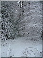
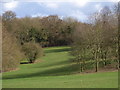
2
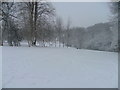
Between Totteridge and Terriers
Picture taken early morning, this is a popular area for local children and adults for starting sledging down the slope after a snowfall.
Image: © Peter Jemmett
Taken: 8 Feb 2007
0.09 miles
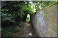
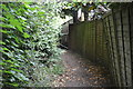
4
Footpath off Totteridge Lane
Footpath off Totteridge Lane into King's Wood
Image: © Shaun Ferguson
Taken: 7 Sep 2008
0.12 miles
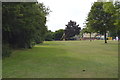
5
Between Hazlemere and Totteridge
This belt of common and woods separates Hazlemere from the Totteridge and Terriers area of Wycombe.
Image: © Andrew Smith
Taken: 2 Apr 2006
0.15 miles