IMAGES TAKEN NEAR TO
Milton Place, HIGH WYCOMBE, HP13 7DN
Introduction
This page details the photographs taken nearby to Milton Place, HP13 7DN by members of the Geograph project.
The Geograph project started in 2005 with the aim of publishing, organising and preserving representative images for every square kilometre of Great Britain, Ireland and the Isle of Man.

There are currently over 7.5m images from over14,400 individuals and you can help contribute to the project by visiting https://www.geograph.org.uk
Image Map
Images are licensed for reuse under creativecommons.org/licenses/by-sa/2.0
Notes
- Clicking on the map will re-center to the selected point.
- The higher the marker number, the further away the image location is from the centre of the postcode.
Image Listing (30 Images Found)
Images are licensed for reuse under creativecommons.org/licenses/by-sa/2.0
Image
Details
Distance
1
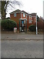
KX 300 Telephone Kiosk and New Housing at Terriers
This photo shows the telephone kiosk in Kingshill Road HP13 5AW with new housing behind it on the A404 Amersham Road. The grey post on the right of the photo refers to a roundabout where the two roads meet. A litter bin full of rubbish is to the left of the telephone kiosk.
Image: © David Hillas
Taken: 2 Mar 2021
0.06 miles
2
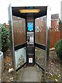
Close up view of KX300 Telephone Kiosk at Terriers
This telephone kiosk is located in Kingshill Road HP13 5AW near the A404 Amersham Road. The blue notice above the payphone mentions about removing the payphone in due course due to lack of usage. A No Smoking notice can be seen at the base of the kiosk.
Image: © David Hillas
Taken: 2 Mar 2021
0.07 miles
4
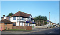
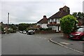
Vets in the Pub
Former pub now the Vets4Pets veterinary surgery.
Image: © Des Blenkinsopp
Taken: 25 Jan 2018
0.12 miles
5
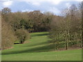
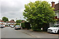
Between Hazlemere and Totteridge
This belt of common and woods separates Hazlemere from the Totteridge and Terriers area of Wycombe.
Image: © Andrew Smith
Taken: 2 Apr 2006
0.12 miles
6
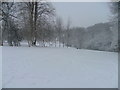
Between Totteridge and Terriers
Picture taken early morning, this is a popular area for local children and adults for starting sledging down the slope after a snowfall.
Image: © Peter Jemmett
Taken: 8 Feb 2007
0.12 miles

9
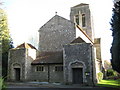
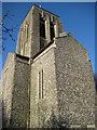
High Wycombe: The Church of St Francis of Assisi, Terriers (1)
This is a classic Sir Giles Gilbert Scott designed church, built of flint with dressed stone corners. It was constructed between 1929 and 1930 on the Amersham Road in the area in High Wycombe known as Terriers. Sir Giles Gilbert Scott (1880 - 1960) was a renowned twentieth century architect who had a range of commissions from Image to Image, with any number of parish church projects, such as this one, in between.
For other views of the Church please see Image and Image
The Church's website is here http://www.terrierschurch.org.uk/index.htm
Image: © Nigel Cox
Taken: 7 Nov 2009
0.17 miles
10
High Wycombe: The Church of St Francis of Assisi, Terriers (2)
This is a classic Sir Giles Gilbert Scott designed church, built of flint with dressed stone corners. It was constructed between 1929 and 1930 on the Amersham Road in the area in High Wycombe known as Terriers. Sir Giles Gilbert Scott (1880 - 1960) was a renowned twentieth century architect who had a range of commissions from Image to Image, with any number of parish church projects, such as this one, in between.
For other views of the Church please see Image and Image
The Church's website is here http://www.terrierschurch.org.uk/index.htm
Image: © Nigel Cox
Taken: 7 Nov 2009
0.17 miles