IMAGES TAKEN NEAR TO
Faulkner Way, HIGH WYCOMBE, HP13 5UA
Introduction
This page details the photographs taken nearby to Faulkner Way, HP13 5UA by members of the Geograph project.
The Geograph project started in 2005 with the aim of publishing, organising and preserving representative images for every square kilometre of Great Britain, Ireland and the Isle of Man.

There are currently over 7.5m images from over14,400 individuals and you can help contribute to the project by visiting https://www.geograph.org.uk
Image Map
Images are licensed for reuse under creativecommons.org/licenses/by-sa/2.0
Notes
- Clicking on the map will re-center to the selected point.
- The higher the marker number, the further away the image location is from the centre of the postcode.
Image Listing (5 Images Found)
Images are licensed for reuse under creativecommons.org/licenses/by-sa/2.0
Image
Details
Distance
1
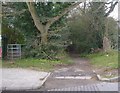
Path next to The Downley School
There are two paths here, one with a kissing gate and one with none. The gates to The Downley School is immediately to the left. The London Green Belt Way follows the path on the right at this point.
Image: © Sean Davis
Taken: 13 Mar 2011
0.04 miles
3
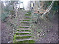
Steps to Nowhere
These steps appear on a bridleway from West Wycombe to Downley Village. There is no evidence of anything at the top. The bridleway veers left from here and, as you can just see, to the right is a sunken track. This is possibly an old river bed and is a public footpath, it is also on the route of the London Green Belt Way.
Image: © Sean Davis
Taken: 13 Mar 2011
0.23 miles
5
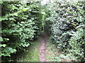
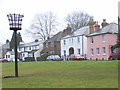
Downley Common: Bridleway to West Wycombe
Ah, the joys of a Chilterns walk - wide open spaces, grand views! Er, not...
Image: © Nigel Cox
Taken: 12 Jul 2008
0.24 miles