IMAGES TAKEN NEAR TO
Bellfield Road, HIGH WYCOMBE, HP13 5HJ
Introduction
This page details the photographs taken nearby to Bellfield Road, HP13 5HJ by members of the Geograph project.
The Geograph project started in 2005 with the aim of publishing, organising and preserving representative images for every square kilometre of Great Britain, Ireland and the Isle of Man.

There are currently over 7.5m images from over14,400 individuals and you can help contribute to the project by visiting https://www.geograph.org.uk
Image Map
Images are licensed for reuse under creativecommons.org/licenses/by-sa/2.0
Notes
- Clicking on the map will re-center to the selected point.
- The higher the marker number, the further away the image location is from the centre of the postcode.
Image Listing (147 Images Found)
Images are licensed for reuse under creativecommons.org/licenses/by-sa/2.0
Image
Details
Distance
5
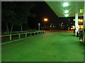
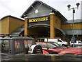
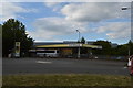
High Wycombe : Morrisons Petrol Station
From the petrol pump.
Image: © Lewis Clarke
Taken: 9 Oct 2016
0.04 miles
6
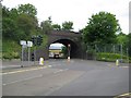
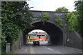
High Wycombe: Bellfield Road railway bridge
A siding, now removed and running approximately parallel to the main railway lines, once ran to a large goods yard to the left of the bridge here, which accounts for the shape and size of the present-day bridge. A fairly new road called Premier Way leads off to the right.
Image: © Nigel Cox
Taken: 5 Jun 2012
0.04 miles