IMAGES TAKEN NEAR TO
Upper Bourne End Lane, HEMEL HEMPSTEAD, HP1 2RP
Introduction
This page details the photographs taken nearby to Upper Bourne End Lane, HP1 2RP by members of the Geograph project.
The Geograph project started in 2005 with the aim of publishing, organising and preserving representative images for every square kilometre of Great Britain, Ireland and the Isle of Man.

There are currently over 7.5m images from over14,400 individuals and you can help contribute to the project by visiting https://www.geograph.org.uk
Image Map
Images are licensed for reuse under creativecommons.org/licenses/by-sa/2.0
Notes
- Clicking on the map will re-center to the selected point.
- The higher the marker number, the further away the image location is from the centre of the postcode.
Image Listing (8 Images Found)
Images are licensed for reuse under creativecommons.org/licenses/by-sa/2.0
Image
Details
Distance
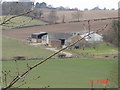
2

Hay baling at Lower Farm
The light-coloured field is a scene of activity as one tractor picks up the rolls of hay and loads them onto the flatbed trailer of another tractor. Lower Farm is to the right. Photo taken from a lay-by on the A41 dual carriageway near Bourne End. This is just outside the square, so image is supplemental.
Image: © Rob Farrow
Taken: 23 Jun 2006
0.03 miles
3
Lower Farm with Great Wood
Lower Farm is on the right of this image, the wood in the background is Great Wood. The lane continues as a bridleway through to Spencer's Farm at Whelpley Hill.
Image: © Rob Farrow
Taken: 9 Aug 2006
0.03 miles
4
Lower Farm
Taken from the bend in the track that links Vale Farm and Lower Farm.
Image: © Rob Farrow
Taken: 9 Aug 2006
0.07 miles
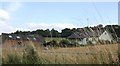
5
Lower Farm and pretend tree
A view of Lower Farm from a couple of hundred yards away showing the farm buildings as well as the farm house.
The tall thin fir tree behind Lower Farm in this photograph is no such thing ! It's a disguised telecoms mast. I remember watching them erecting this bit of subterfuge several years ago.
Image: © Rob Farrow
Taken: 9 Aug 2006
0.07 miles
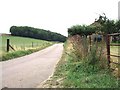
6
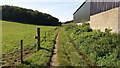
Bridleway passing Lower Farm
Bridleway passing Lower Farm heading up past Great Wood
Image: © Shaun Ferguson
Taken: 28 Sep 2020
0.08 miles
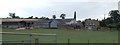
7
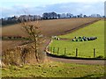
Farmland, Bovingdon
A view of rolling farmland from the junction of bridleways at Lower Farm.
Image: © Andrew Smith
Taken: 28 Jan 2012
0.10 miles
8
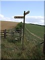
Bridleway & footpath near Lower Farm
This signpost marks the junction of a footpath from the Southeast with the bridleway that links Vale Farm with Lower Farm.
Image: © Rob Farrow
Taken: 9 Aug 2006
0.11 miles