IMAGES TAKEN NEAR TO
Walnut Tree Close, HIGH WYCOMBE, HP12 4DE
Introduction
This page details the photographs taken nearby to Walnut Tree Close, HP12 4DE by members of the Geograph project.
The Geograph project started in 2005 with the aim of publishing, organising and preserving representative images for every square kilometre of Great Britain, Ireland and the Isle of Man.

There are currently over 7.5m images from over14,400 individuals and you can help contribute to the project by visiting https://www.geograph.org.uk
Image Map
Images are licensed for reuse under creativecommons.org/licenses/by-sa/2.0
Notes
- Clicking on the map will re-center to the selected point.
- The higher the marker number, the further away the image location is from the centre of the postcode.
Image Listing (18 Images Found)
Images are licensed for reuse under creativecommons.org/licenses/by-sa/2.0
Image
Details
Distance
1
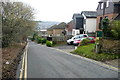
Houses on Toweridge Lane
In the suburb of Sands. There is a variety of 1980s and 1990s houses of different designs along this steep road.
Image: © Graham Horn
Taken: 29 Jan 2012
0.13 miles
2
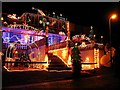
Annual Display, Christmas 2006
Here in High Wycombe, some residents don't stint on the decorations. No flash was needed. The display gave out considerable heat and there are large collection boxes on the pavement: not as I thought for charity, but to help pay the electricity.
Image: © Ian Mulder
Taken: 16 Dec 2006
0.13 miles
3
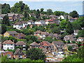
Sands, High Wycombe
Looking across to houses on Hylton Road and Pinewood Road from the hillside below Desborough Castle.
Image: © Andrew Smith
Taken: 3 Jul 2010
0.13 miles
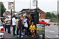
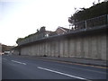
7
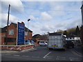
The entrance to Tesco Express on Chapel Lane
In 2012 this was a vacant lot, but I don't know for how long altogether.
Image: © David Howard
Taken: 20 Mar 2016
0.17 miles
9
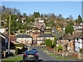
Hilly suburban High Wycombe
Looking down Roundwood Road with Lane End Road at the bottom and Pinewood Road going up the other side.
Image: © Robin Webster
Taken: 23 Nov 2017
0.17 miles