IMAGES TAKEN NEAR TO
Chapel Lane, HIGH WYCOMBE, HP12 4BN
Introduction
This page details the photographs taken nearby to Chapel Lane, HP12 4BN by members of the Geograph project.
The Geograph project started in 2005 with the aim of publishing, organising and preserving representative images for every square kilometre of Great Britain, Ireland and the Isle of Man.

There are currently over 7.5m images from over14,400 individuals and you can help contribute to the project by visiting https://www.geograph.org.uk
Image Map (Loading...)


Getting Data...Please wait
Leaflet Map data © OpenStreetMap
Images are licensed for reuse under creativecommons.org/licenses/by-sa/2.0
Notes
- Clicking on the map will re-center to the selected point.
- The higher the marker number, the further away the image location is from the centre of the postcode.
Image Listing (20 Images Found)
Images are licensed for reuse under creativecommons.org/licenses/by-sa/2.0
Image
Details
Distance
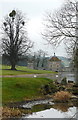
1
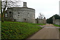
Entrance to Park Farm
This is the eastern boundary of the West Wycombe estate. Behind this flint gatehouse there appears to be a much more modest house.
Image: © Graham Horn
Taken: 29 Jan 2012
0.03 miles
2
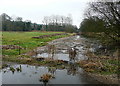
River Wye
The more southerly of the braided streams of the River Wye. This is part of the West Wycombe estate and is the last rural stretch before it enters High Wycombe.
Image: © Graham Horn
Taken: 29 Jan 2012
0.05 miles
3
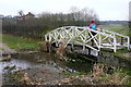
Footbridge to Park Farm
This ornate footbridge takes a public footpath across the River Wye, here dammed and controlled.
Image: © Graham Horn
Taken: 29 Jan 2012
0.06 miles
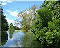
4
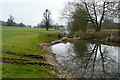
River Wye in West Wycombe Park
This is a view towards Sawmill House, within the park. The river is dammed here to form a lake viewable from the house.
Image: © Graham Horn
Taken: 29 Jan 2012
0.07 miles
5
View towards Sawmill House
This is a view towards Sawmill House, within the park. The river is dammed here to form a lake viewable from the house.
Image: © Graham Horn
Taken: 29 Jan 2012
0.07 miles
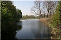
6
River Wye, West Wycombe Park
The last fling of the Wye as ornamental water on a country estate. This is taken from the bridge where the river shrinks back to a normal size and becomes an urban watercourse around the backs of houses and factories.
Image: © Des Blenkinsopp
Taken: 3 Jun 2013
0.11 miles
7
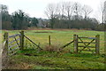
Farmland at West Wycombe Park
The buildings of High Wycombe stop rather abruptly as this land is all part of the farm belonging to West Wycombe Park. Behind me is the River Wye.
Image: © Graham Horn
Taken: 29 Jan 2012
0.11 miles
8
High Wycombe
Taken from the bridge on the A4010 in the southwest corner of the square this pictures shows an oasis of calm off a busy road in a busy square of residential estates and industrial complexes. .
Image: © Brendan and Ruth McCartney
Taken: 21 Apr 2005
0.13 miles
9
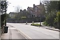
High Wycombe
A typical view looking south on the A4010. The building on the right is a large house carrying the date 1912. The square is busy residential.
Image: © Brendan and Ruth McCartney
Taken: 21 Apr 2005
0.15 miles
10
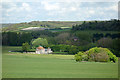
Towards Sawmill House
Looking northwards down into the Wye Valley from woodland beside Towerage Lane.
This square ends about where the track is, beyond the clump of trees. The house is in SU8394.
Sawmill House is a mid C18 building on the West Wycombe Estate. Originally built as a working sawmill it appears to owe more to Chateaux on the Loire than to the timber industry.
Image: © Des Blenkinsopp
Taken: 2 May 2017
0.15 miles