IMAGES TAKEN NEAR TO
Maurice Mews, HIGH WYCOMBE, HP12 3GE
Introduction
This page details the photographs taken nearby to Maurice Mews, HP12 3GE by members of the Geograph project.
The Geograph project started in 2005 with the aim of publishing, organising and preserving representative images for every square kilometre of Great Britain, Ireland and the Isle of Man.

There are currently over 7.5m images from over14,400 individuals and you can help contribute to the project by visiting https://www.geograph.org.uk
Image Map
Images are licensed for reuse under creativecommons.org/licenses/by-sa/2.0
Notes
- Clicking on the map will re-center to the selected point.
- The higher the marker number, the further away the image location is from the centre of the postcode.
Image Listing (17 Images Found)
Images are licensed for reuse under creativecommons.org/licenses/by-sa/2.0
Image
Details
Distance
1
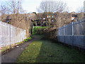
Footpath over the railways bridge
Footpath over the railway bridge up to Cotswold Way.
Image: © Shaun Ferguson
Taken: 25 Feb 2008
0.06 miles
2
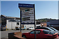
Pilot Trading Estate
A commercial area off West Wycombe Road.
Image: © Bill Boaden
Taken: 20 Apr 2018
0.08 miles
3
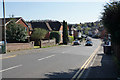
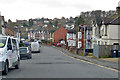
Desborough Park Road
A residential road off West Wycombe Road. The nearest thing to a park now in the locality is Desborough Recreation Ground.
Image: © Bill Boaden
Taken: 20 Apr 2018
0.12 miles
4
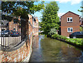
River Wye at Desborough Park Road
Apart from a few hundred metres in the very centre of town the River Wye manages to stay unculverted for most of its journey through urban Wycombe.
Image: © Des Blenkinsopp
Taken: 3 Jun 2013
0.14 miles
6
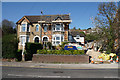
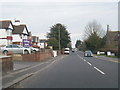
House refurbishment on West Wycombe Road
The housing rises steadily up the hillside behind.
Image: © Bill Boaden
Taken: 20 Apr 2018
0.16 miles
8
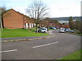
High Wycombe: Mendip Way
The staggered arrays of houses running up and down the hillsides on Mendip Way and its parallel roads, Cumbrian, Brecon and Cotswold Ways appear just as amorphous orange infills on the Ordnance Survey 1:50,000 scale map, but look at the larger scale 1:25,000 scale maps and they appear as a series of wriggly worms! Practically this is an interesting modern alternative to the stepped housing terraces that used to be built on steep hillsides.
Image: © Nigel Cox
Taken: 7 Nov 2009
0.19 miles
9
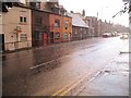
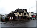
Victorian Cottages on West Wycombe Road
During heavy rain in late July 2007, when parts of England were flooded.
Image: © Ian Mulder
Taken: 26 Jul 2007
0.20 miles