IMAGES TAKEN NEAR TO
Prestwood Close, HIGH WYCOMBE, HP12 3DE
Introduction
This page details the photographs taken nearby to Prestwood Close, HP12 3DE by members of the Geograph project.
The Geograph project started in 2005 with the aim of publishing, organising and preserving representative images for every square kilometre of Great Britain, Ireland and the Isle of Man.

There are currently over 7.5m images from over14,400 individuals and you can help contribute to the project by visiting https://www.geograph.org.uk
Image Map (Loading...)


Getting Data...Please wait
Leaflet Map data © OpenStreetMap
Images are licensed for reuse under creativecommons.org/licenses/by-sa/2.0
Notes
- Clicking on the map will re-center to the selected point.
- The higher the marker number, the further away the image location is from the centre of the postcode.
Image Listing (11 Images Found)
Images are licensed for reuse under creativecommons.org/licenses/by-sa/2.0
Image
Details
Distance
1
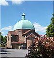
Church of St Mary & St George
Built in Byzantine style in 1938, the green copper dome is a Wycombe landmark.
The church website admits that the building is sometimes mistaken for a mosque.
Image: © Des Blenkinsopp
Taken: 3 Jun 2013
0.05 miles
3
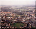
Desborough Castle, High Wycombe from the air
The clump of trees in the centre of the picture cover the site of Desborough Castle, an ancient hill fort on the outskirts of High Wycombe. The open space in the foreground is between Deeds Grove and Carrington Road. The picture was taken from a Piper Cherokee Arrow on approach to Wycombe Air Park - see picture of the airfield in square Image
Image: © Stephen Williams
Taken: 11 Feb 1988
0.14 miles
4
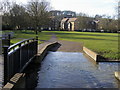
Desborough Park
The River Wye in Desborough Park
Image: © Shaun Ferguson
Taken: 25 Feb 2008
0.14 miles
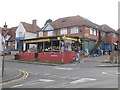
5
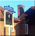
The Half Moon
I liked the style of the building (1930s) and the inn sign so much that it was doomed. Now they have modernised the sign to some meaningless moon icon and destroyed the character of a once fine pub. Not the only one to suffer this fate in Wycombe.
Image: © Ian Mulder
Taken: 10 Oct 2004
0.18 miles
6
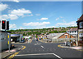
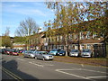
Desborough Park Road
Crossing Dashwood Avenue.
Image: © Des Blenkinsopp
Taken: 3 Jun 2013
0.19 miles
7
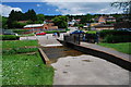
Ford at High Wycombe
This ford is found on the footpath beside the playground in a suburb of High Wycombe.
Image: © John Walton
Taken: 2 Jun 2013
0.20 miles
8
High Wycombe: Millbrook Combined School
As with many schools these days this one, in Mill End Road, has had a chequered history in terms of the age group that it has served, according to the prevailing dictats of both national and local government, and the changing demographics of the local population. Consequently it has had several names thus:
1936: Mill End Secondary School (11 to 16 year old children)
1973: Sands County Middle School (8 to 12 year old children)
1998: Sands Junior School (7 to 11 year old children)
1999: Millbrook Combined School (3 to 11 year old children)
It is interesting to compare the Ordnance Survey's current 1:10,000 scale map with its equivalent from 1938 showing the school as originally built. Although the basic pattern is still the same, with a few extensions added, evidently the school originally had a central segment, as long as this frontage, which has now been broken in two to create a central courtyard.
The whole building is topped by the attractive central clock tower which forms the School badge. As ever it is good to report that the clock was telling the right time. The School's website is here http://www.millbrook.bucks.sch.uk/default.asp
Image: © Nigel Cox
Taken: 7 Nov 2009
0.22 miles
9
Thara Stores
The biggest Pakistani/Kashmiri supermarket in High Wycombe
Image: © Ian Mulder
Taken: 12 Aug 2007
0.22 miles