IMAGES TAKEN NEAR TO
Ellsworth Road, HIGH WYCOMBE, HP11 2TU
Introduction
This page details the photographs taken nearby to Ellsworth Road, HP11 2TU by members of the Geograph project.
The Geograph project started in 2005 with the aim of publishing, organising and preserving representative images for every square kilometre of Great Britain, Ireland and the Isle of Man.

There are currently over 7.5m images from over14,400 individuals and you can help contribute to the project by visiting https://www.geograph.org.uk
Image Map
Images are licensed for reuse under creativecommons.org/licenses/by-sa/2.0
Notes
- Clicking on the map will re-center to the selected point.
- The higher the marker number, the further away the image location is from the centre of the postcode.
Image Listing (23 Images Found)
Images are licensed for reuse under creativecommons.org/licenses/by-sa/2.0
Image
Details
Distance
1
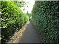
High Wycombe: Footpath between Marlow Road and Shelley Road
The hilly ground south of High Wycombe was criss-crossed with several public footpaths long before the houses, schools and factories arrived. However when they were built the old footpath routes were kept and this is one running between Marlow Road and Shelley Road, at the start of the long straight section just down from Marlow Road.
Image: © Nigel Cox
Taken: 25 Jul 2015
0.03 miles
2
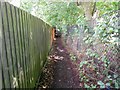
High Wycombe: Footpath between Marlow Road and Shelley Road
The hilly ground south of High Wycombe was criss-crossed with several public footpaths long before the houses, schools and factories arrived. However when they were built the old footpath routes were kept and this is one running between Marlow Road and Shelley Road, with the playing fields of Wycombe High School on the right.
Image: © Nigel Cox
Taken: 25 Jul 2015
0.12 miles
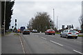
3
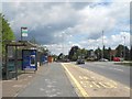
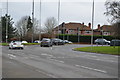
High Wycombe: Marlow Hill bus stops
These are mostly schools bus stops, but one public route, Purple 36, goes down Marlow Hill from here to High Wycombe town centre.
Image: © Nigel Cox
Taken: 25 Jul 2015
0.16 miles
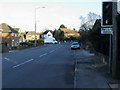
4
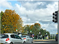
High Wycombe : Marlow Hill
Heading into the town on Marlow Hill.
Image: © Lewis Clarke
Taken: 9 Oct 2016
0.16 miles
5
Lancaster Road
Lancaster Road on Cressex Industrial Estate heading down to Desborough Avenue
Image: © Shaun Ferguson
Taken: 7 Mar 2008
0.16 miles
7
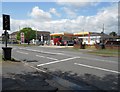
High Wycombe: Shell Cressex filling station
The garage is on Marlow Road at its junction with Desborough Avenue. At the time the photograph was taken petrol was 114.9 pence and diesel 113.9 pence per litre, the first time that the latter had been cheaper than the former for many years. The traffic lights are part-time signals.
Image: © Nigel Cox
Taken: 25 Jul 2015
0.18 miles
8
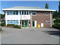
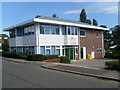
Former High Wycombe Driving Test Centre (1)
Situated in Wellington Road off Lancaster Road, this DTC replaced the DTC in Baker Street off Desborough Avenue in the mid-2000s. Parking area for vehicles can be seen in front of the DTC. Its postcode is HP12 3PS. Update: this DTC ceased holding driving tests after Friday 12th March 2021.
Image: © David Hillas
Taken: 18 Aug 2012
0.19 miles
10
Former High Wycombe Driving Test Centre (2)
This DTC, called Trenchard House, in Wellington Road only takes practical driving tests. Theory tests are held in Aylesbury, Milton Keynes, Oxford, Reading or Slough nearby. Update: this DTC ceased holding driving tests after Friday 12th March 2021.
Image: © David Hillas
Taken: 18 Aug 2012
0.19 miles