IMAGES TAKEN NEAR TO
Crispin Way, HIGH WYCOMBE, HP11 1PP
Introduction
This page details the photographs taken nearby to Crispin Way, HP11 1PP by members of the Geograph project.
The Geograph project started in 2005 with the aim of publishing, organising and preserving representative images for every square kilometre of Great Britain, Ireland and the Isle of Man.

There are currently over 7.5m images from over14,400 individuals and you can help contribute to the project by visiting https://www.geograph.org.uk
Image Map
Images are licensed for reuse under creativecommons.org/licenses/by-sa/2.0
Notes
- Clicking on the map will re-center to the selected point.
- The higher the marker number, the further away the image location is from the centre of the postcode.
Image Listing (10 Images Found)
Images are licensed for reuse under creativecommons.org/licenses/by-sa/2.0
Image
Details
Distance
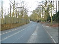
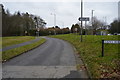
1
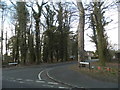
Knights Templar Way at the junction of Daws Hill Lane
Image: © David Howard
Taken: 8 Mar 2015
0.10 miles
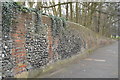
2
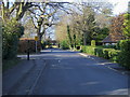
St Augustines school lane
St Augustines school lane off Daws Hill Lane
Image: © Shaun Ferguson
Taken: 7 Mar 2008
0.11 miles
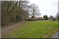
3
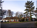
Knights Templar Way
A rather well-to-do and leafy estate on the southern edge of High Wycombe.
Image: © Andrew Smith
Taken: 4 Apr 2006
0.17 miles
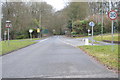
4
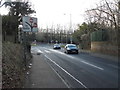
Daws Hill Lane, High Wycombe
Looking towards the A404
Image: © David Howard
Taken: 8 Mar 2015
0.18 miles
10
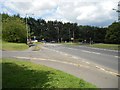
High Wycombe: Daws Hill Lane
This is the approach of Daws Hill Lane to its junction with the A404 Marlow Hill. The original route of Marlow Hill, before it was straightened, cut across the foreground here and followed the now dead-end road to the left.
Image: © Nigel Cox
Taken: 25 Jul 2015
0.24 miles