IMAGES TAKEN NEAR TO
Kingsmead Road, HIGH WYCOMBE, HP11 1JA
Introduction
This page details the photographs taken nearby to Kingsmead Road, HP11 1JA by members of the Geograph project.
The Geograph project started in 2005 with the aim of publishing, organising and preserving representative images for every square kilometre of Great Britain, Ireland and the Isle of Man.

There are currently over 7.5m images from over14,400 individuals and you can help contribute to the project by visiting https://www.geograph.org.uk
Image Map
Images are licensed for reuse under creativecommons.org/licenses/by-sa/2.0
Notes
- Clicking on the map will re-center to the selected point.
- The higher the marker number, the further away the image location is from the centre of the postcode.
Image Listing (20 Images Found)
Images are licensed for reuse under creativecommons.org/licenses/by-sa/2.0
Image
Details
Distance
1
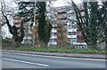
Westfields House, Wycombe Marsh
This block was converted from offices to flats in 2016
Image: © David Howard
Taken: 17 Feb 2022
0.11 miles
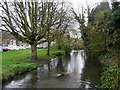
2
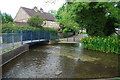
Former Ford at High Wycombe
This ford on the River Wye is found at the end of Beech Road in a residential suburb of High Wycombe and has been closed by the addition of bollards at each end.
Image: © John Walton
Taken: 2 Jun 2013
0.11 miles
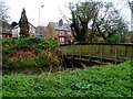
3
Wycombe Marsh Brook: Former Beech Road ford
The watercourse that the ford used to cross here is actually a braid of the main River Wye known as the Back Stream or Wycombe Marsh Brook. There used to be a paper mill just upstream of the ford here, known as Beech Mill, hence the probable origin of the road name.
Image: © Nigel Cox
Taken: 5 Jun 2012
0.12 miles
4
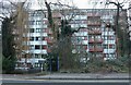
Westfields House, Wycombe Marsh
This block was converted from offices to flats in 2016
Image: © David Howard
Taken: 17 Feb 2022
0.12 miles
6
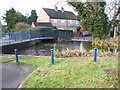
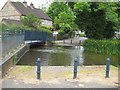
Bridge on the River Wye
A ford, now closed to traffic, in Wycombe Marsh.
Image: © Andrew Smith
Taken: 31 Dec 2005
0.13 miles
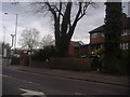
9
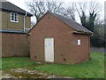
Telephone Repeater Station, King's Mead (1)
This photo shows what maybe a telephone repeater station in Gomm Road near the A40 London Road. It has a BT warning notice on its side and a small blue notice on its door, so it may still be in use by BT at the present time.
Image: © David Hillas
Taken: 11 Feb 2015
0.15 miles
10
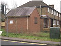
Telephone Repeater Station, King's Mead (2)
This photo shows what maybe a telephone repeater station in Gomm Road with the houses on the A40 London Road behind it. There is a BT warning notice on that building so it may still be in use by that company. To the right of the photo is a green BT cabinet box containing telephone wiring that connects with the houses and other buildings nearby.
Image: © David Hillas
Taken: 11 Feb 2015
0.15 miles