IMAGES TAKEN NEAR TO
Winchbottom Lane, HIGH WYCOMBE, HP10 9QE
Introduction
This page details the photographs taken nearby to Winchbottom Lane, HP10 9QE by members of the Geograph project.
The Geograph project started in 2005 with the aim of publishing, organising and preserving representative images for every square kilometre of Great Britain, Ireland and the Isle of Man.

There are currently over 7.5m images from over14,400 individuals and you can help contribute to the project by visiting https://www.geograph.org.uk
Image Map
Images are licensed for reuse under creativecommons.org/licenses/by-sa/2.0
Notes
- Clicking on the map will re-center to the selected point.
- The higher the marker number, the further away the image location is from the centre of the postcode.
Image Listing (15 Images Found)
Images are licensed for reuse under creativecommons.org/licenses/by-sa/2.0
Image
Details
Distance
1
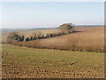
Fields near High Wycombe
Photo looking west at noon from footpath, taken near the top of Winchbottom Lane, which is behind the hedge across the photo.
Image: © David Hawgood
Taken: 5 Feb 2006
0.10 miles
2
Road away from Hard to Find Farm
I found it by the simple expedient of taking the wrong turning.
Image: © Robin Webster
Taken: 2 Feb 2014
0.12 miles
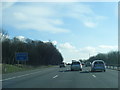
4
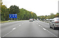
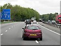
M40 at High Wycombe
Northbound, between junctions 3 and 4
Image: © MrC
Taken: 13 Oct 2012
0.14 miles
5
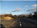
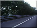
Heath End Road, High Wycombe
Just south of the urban area
Image: © David Howard
Taken: 8 Mar 2015
0.14 miles
6
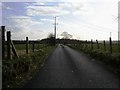
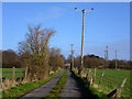
Lane down to Hard to find Farm
Lane down to Hard to find Farm off Heath End Road
Image: © Shaun Ferguson
Taken: 7 Mar 2008
0.15 miles
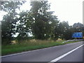
9
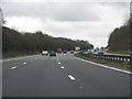
M40 Motorway - southbound near Abbey Barn Farm
Image: © K. Whatley
Taken: 5 Apr 2010
0.16 miles