IMAGES TAKEN NEAR TO
Ashwells Manor Drive, HIGH WYCOMBE, HP10 8EU
Introduction
This page details the photographs taken nearby to Ashwells Manor Drive, HP10 8EU by members of the Geograph project.
The Geograph project started in 2005 with the aim of publishing, organising and preserving representative images for every square kilometre of Great Britain, Ireland and the Isle of Man.

There are currently over 7.5m images from over14,400 individuals and you can help contribute to the project by visiting https://www.geograph.org.uk
Image Map (Loading...)


Getting Data...Please wait
Leaflet Map data © OpenStreetMap
Images are licensed for reuse under creativecommons.org/licenses/by-sa/2.0
Notes
- Clicking on the map will re-center to the selected point.
- The higher the marker number, the further away the image location is from the centre of the postcode.
Image Listing (45 Images Found)
Images are licensed for reuse under creativecommons.org/licenses/by-sa/2.0
Image
Details
Distance
3
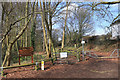
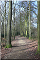
Bridleway and Footpath Gate into Kings Wood
Footpath and bridleway run side by side for a while.
Image: © Des Blenkinsopp
Taken: 4 Mar 2019
0.11 miles
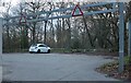
6
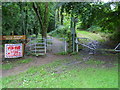
Bridleway into King's Wood
Bridleway into King's Wood off Cock Lane
Image: © Shaun Ferguson
Taken: 7 Sep 2008
0.15 miles
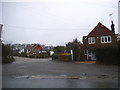
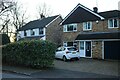
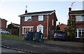
8
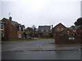
Kite Wood Road
The building layout on the map doesn't match what is here now so this looks like a recent redevelopment of a brownfield site.
Image: © Des Blenkinsopp
Taken: 4 Mar 2019
0.18 miles
10
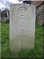
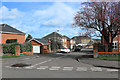
Pvt. F H Eustace
See http://www.cwgc.org/search/casualty_details.aspx?casualty=344191 for a few more background details.
Image: © Mr Ignavy
Taken: 22 Feb 2009
0.21 miles