IMAGES TAKEN NEAR TO
Millstream Way, HIGH WYCOMBE, HP10 0NL
Introduction
This page details the photographs taken nearby to Millstream Way, HP10 0NL by members of the Geograph project.
The Geograph project started in 2005 with the aim of publishing, organising and preserving representative images for every square kilometre of Great Britain, Ireland and the Isle of Man.

There are currently over 7.5m images from over14,400 individuals and you can help contribute to the project by visiting https://www.geograph.org.uk
Image Map
Images are licensed for reuse under creativecommons.org/licenses/by-sa/2.0
Notes
- Clicking on the map will re-center to the selected point.
- The higher the marker number, the further away the image location is from the centre of the postcode.
Image Listing (23 Images Found)
Images are licensed for reuse under creativecommons.org/licenses/by-sa/2.0
Image
Details
Distance
3
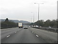
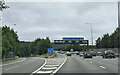
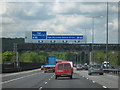
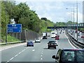
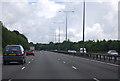
M40 Motorway - northbound approaching junction 3
Note that lane 1 is already marked for the lane drop at the High Wycombe (East) junction a short distance ahead.
Image: © K. Whatley
Taken: 7 Apr 2010
0.10 miles
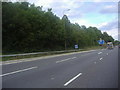
5
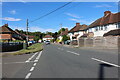
A40 London Road towards High Wycombe
La Limor bar and restaurant on the left.
Image: © Robin Webster
Taken: 8 Dec 2019
0.13 miles
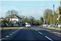
6
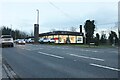
Rickshaw restaurant on London Road, Loudwater
It replaced the Bombay Grill Indian a few months ago.
Image: © David Howard
Taken: 17 Feb 2022
0.13 miles
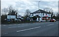
8
Hyundai garage on London Road, Loudwater
Image: © David Howard
Taken: 17 Feb 2022
0.14 miles