IMAGES TAKEN NEAR TO
Whitepit Lane, HIGH WYCOMBE, HP10 0EX
Introduction
This page details the photographs taken nearby to Whitepit Lane, HP10 0EX by members of the Geograph project.
The Geograph project started in 2005 with the aim of publishing, organising and preserving representative images for every square kilometre of Great Britain, Ireland and the Isle of Man.

There are currently over 7.5m images from over14,400 individuals and you can help contribute to the project by visiting https://www.geograph.org.uk
Image Map
Images are licensed for reuse under creativecommons.org/licenses/by-sa/2.0
Notes
- Clicking on the map will re-center to the selected point.
- The higher the marker number, the further away the image location is from the centre of the postcode.
Image Listing (31 Images Found)
Images are licensed for reuse under creativecommons.org/licenses/by-sa/2.0
Image
Details
Distance
1
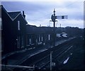
Wooburn Green Railway Station, Bucks
Taken in April, 1970, this station was situated on the railway line between Bourne End and High Wycombe which closed a month later. There is now no remains of this station in Old Station Way, Wooburn Green, HP10 0HZ.
Image: © David Hillas
Taken: 25 Apr 1970
0.02 miles
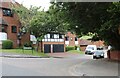
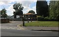
3
Wooburn Green at the junction of White Pit Lane
Image: © David Howard
Taken: 8 Mar 2015
0.07 miles

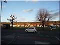
6
Soho Mills Industrial Estate, Wooburn Green
Image: © David Howard
Taken: 12 Jun 2022
0.11 miles
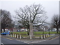
8

Wooburn Green's Memorial
On the village green.
One cross for every casualty from the parish.
Image: © Des Blenkinsopp
Taken: 8 Nov 2018
0.11 miles
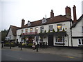
10
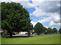
Wooburn Green
Looking across the neatly mown green and its trees towards the A4094 road.
Image: © Nigel Cox
Taken: 8 Jul 2007
0.11 miles