IMAGES TAKEN NEAR TO
The Gables, KNARESBOROUGH, HG5 9EB
Introduction
This page details the photographs taken nearby to The Gables, HG5 9EB by members of the Geograph project.
The Geograph project started in 2005 with the aim of publishing, organising and preserving representative images for every square kilometre of Great Britain, Ireland and the Isle of Man.

There are currently over 7.5m images from over14,400 individuals and you can help contribute to the project by visiting https://www.geograph.org.uk
Image Map
Images are licensed for reuse under creativecommons.org/licenses/by-sa/2.0
Notes
- Clicking on the map will re-center to the selected point.
- The higher the marker number, the further away the image location is from the centre of the postcode.
Image Listing (66 Images Found)
Images are licensed for reuse under creativecommons.org/licenses/by-sa/2.0
Image
Details
Distance
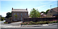
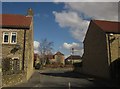
2
Old farm buildings at the corner of Scriven Road and Greengate Lane
Image: © habiloid
Taken: 10 Mar 2013
0.05 miles
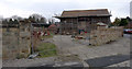
3
Disused farm buildings at the corner of Scriven Road and Greengate Lane
The wall running down Scriven Road once formed the boundary of the Slingsby family's parkland.
Image: © habiloid
Taken: 5 Apr 2008
0.05 miles
4
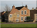
Manor House Scriven
By no means the largest house in the village, but probably one of the oldest. There is a coat of arms, a latin inscription and various carved stones in one wall, which appear to have been brought from St Robert's Priory in Knaresborough, presumably after the dissolution. Constructed from a variety of stone, rubble and hand made brick.
Image: © Gordon Hatton
Taken: 1 Feb 2007
0.06 miles
5
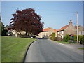
The Gables, Scriven
This modern cul-de-sac forms a crossroads with Greengate Lane and Scriven Road ata a mini-roundabout just behind the camera.
Image: © Derek Harper
Taken: 5 Apr 2013
0.06 miles
6
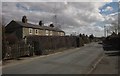
Pleasant Row, Scriven
A terrace of five cottages on Greengate Lane. Turning off immediately after them, and carrying with it the parish boundary between Scriven (left) and Knaresborough (ahead and down the lane), is the intriguingly-named Dumb Pots Lane.
Image: © Derek Harper
Taken: 5 Apr 2013
0.07 miles
7
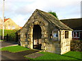
Old Scriven Memorial
Inside is a plaque to local men who died in both World Wars.
Image: © David Rogers
Taken: 23 Nov 2009
0.07 miles
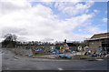
9
The Green
The Green in Scriven, on the outskirts of Knaresborough.
Image: © DS Pugh
Taken: 21 Apr 2011
0.09 miles
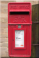
10
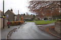
Market Flat Lane, Scriven
A closer view of the postbox can be seen here: Image
Image: © Mark Anderson
Taken: 18 Nov 2013
0.09 miles