IMAGES TAKEN NEAR TO
Shepherds Court, KNARESBOROUGH, HG5 9AH
Introduction
This page details the photographs taken nearby to Shepherds Court, HG5 9AH by members of the Geograph project.
The Geograph project started in 2005 with the aim of publishing, organising and preserving representative images for every square kilometre of Great Britain, Ireland and the Isle of Man.

There are currently over 7.5m images from over14,400 individuals and you can help contribute to the project by visiting https://www.geograph.org.uk
Image Map
Images are licensed for reuse under creativecommons.org/licenses/by-sa/2.0
Notes
- Clicking on the map will re-center to the selected point.
- The higher the marker number, the further away the image location is from the centre of the postcode.
Image Listing (58 Images Found)
Images are licensed for reuse under creativecommons.org/licenses/by-sa/2.0
Image
Details
Distance
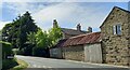
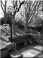
1
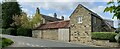
Scotton, Moorcock Hall Farm
According to the OS benchmark database there was a mark cut into the right stonework of the gable end. There has been considerable renovations done to the old farmhouse in recent years, and no benchmark was found.
Image: © Mel Towler
Taken: 8 May 2022
0.05 miles
2
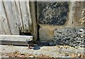
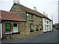
Scotton village
This is a picture of part of the stone wall of a private residence on the building opposite the north end of Mire Syke Lane. This stone is immediately right of a wooden sliding door. It is the lowest course of stone and shows a surveyor's cut mark. The arrowheads which are part of the mark have been obscured, and likely due to the raised pavement which will have been put in place after the cut mark.
Image: © Mel Towler
Taken: 15 Jun 2021
0.06 miles
3
Scotton village
The private residence is the building opposite the north end of Mire Syke Lane. Immediately right of the sliding door, on the lowest course of stone is a surveyor's cut mark. The arrowheads which are part of the mark have been obscured, and likely due to the pavement which will have been put in place after the cut mark.
Image: © Mel Towler
Taken: 15 Jun 2021
0.06 miles
4
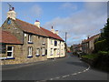
Scotton
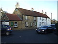
The village of Scotton. This pub is called the Guy Fawkes Arms.
Image: © DS Pugh
Taken: 6 Sep 2006
0.07 miles
5
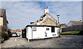
The Guy Fawkes Arms seen from Havikil Lane, Scotton
Image: © habiloid
Taken: 27 Mar 2022
0.13 miles
6
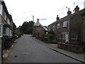
Guy Fawkes Arms
Looking through the village of Scotton.
Image: © DS Pugh
Taken: 26 May 2014
0.13 miles
8
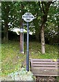
Direction Sign – Signpost on New Road in Scotton
Located beside a bench on the south side of the junction of Havikil Lane, New Road and Main Street in Scotton parish. No arms and annulus and bar finial. See also https://www.geograph.org.uk/photo/7131501.
Milestone Society National ID: YW_SE3259
Image: © T Exley
Taken: 1 Sep 2023
0.13 miles