IMAGES TAKEN NEAR TO
Bridge Close, KNARESBOROUGH, HG5 8PN
Introduction
This page details the photographs taken nearby to Bridge Close, HG5 8PN by members of the Geograph project.
The Geograph project started in 2005 with the aim of publishing, organising and preserving representative images for every square kilometre of Great Britain, Ireland and the Isle of Man.

There are currently over 7.5m images from over14,400 individuals and you can help contribute to the project by visiting https://www.geograph.org.uk
Image Map
Images are licensed for reuse under creativecommons.org/licenses/by-sa/2.0
Notes
- Clicking on the map will re-center to the selected point.
- The higher the marker number, the further away the image location is from the centre of the postcode.
Image Listing (455 Images Found)
Images are licensed for reuse under creativecommons.org/licenses/by-sa/2.0
Image
Details
Distance
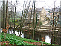
4
Knaresborough, Waterside
The benchmark is cut into the roadside wall on the north side of Waterside and the river.
Image: © Mel Towler
Taken: 19 Jan 2023
0.02 miles
5
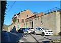
Knaresborough, Waterside
There is a benchmark cut into the roadside wall on the north side of Waterside and the river. The cutmark is on a left cornerstone, behind the 2nd white car.
Image: © Mel Towler
Taken: 19 Jan 2023
0.02 miles
6
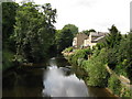
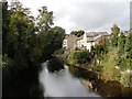
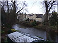
River Nidd, Knaresborough
Looking upstream from Low Bridge
Image: © Dr Neil Clifton
Taken: 16 Jul 2009
0.03 miles
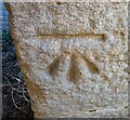
7
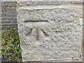
Ordnance Survey Cut Mark
This can be found on a wall in Waterside.
For more detail see : http://www.bench-marks.org.uk/bm49467
Image: © Peter Wood
Taken: 9 Jun 2013
0.03 miles
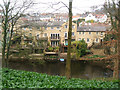
10
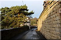
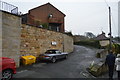
Waterside, Knaresborough
Narrow lane, with limited vehicular access that loosely follows the River Nidd between Low and High Bridges in Knaresborough
Image: © Chris Heaton
Taken: 31 Dec 2014
0.04 miles