IMAGES TAKEN NEAR TO
Waterside, KNARESBOROUGH, HG5 8DE
Introduction
This page details the photographs taken nearby to Waterside, HG5 8DE by members of the Geograph project.
The Geograph project started in 2005 with the aim of publishing, organising and preserving representative images for every square kilometre of Great Britain, Ireland and the Isle of Man.

There are currently over 7.5m images from over14,400 individuals and you can help contribute to the project by visiting https://www.geograph.org.uk
Image Map
Images are licensed for reuse under creativecommons.org/licenses/by-sa/2.0
Notes
- Clicking on the map will re-center to the selected point.
- The higher the marker number, the further away the image location is from the centre of the postcode.
Image Listing (1290 Images Found)
Images are licensed for reuse under creativecommons.org/licenses/by-sa/2.0
Image
Details
Distance
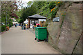
2
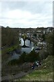
Path near the castle
Looking down a path leading down to the riverside with the viaduct in the distance.
Image: © DS Pugh
Taken: 28 Mar 2021
0.01 miles
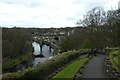
3
Climbing up from the river
With Knaresborough viaduct in the distance.
Image: © DS Pugh
Taken: 28 Mar 2021
0.01 miles
5
Cut Bench Mark, Waterside
A closer view of the bench mark can be seen here: Image
Image: © Mark Anderson
Taken: 16 May 2010
0.02 miles
6
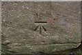
Cut Bench Mark (close-up)
Bench Marks Database: http://www.bench-marks.org.uk/bm34375
Image: © Mark Anderson
Taken: 16 May 2010
0.02 miles
8
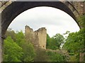
Knaresborough Castle
Knaresborough Castle seen through an arch of the railway bridge, from a rowing boat on the River Nidd. (You will have to imagine the boat hire landing stages which were on the bottom of the original picture which I cut off, along with the rower's face!)
Image: © Rich Tea
Taken: 4 May 2003
0.02 miles
9
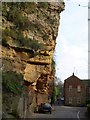
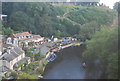
Overhanging cliff, Knaresborough
Castle Crag overhangs Waterside on the east bank of the Nidd, below Knaresborough Castle. On the right is part of the Castle Mills complex; possibly originally a paper mill, it operated as a cotton and then a linen mill until 1972.
Image: © Derek Harper
Taken: 11 Apr 2009
0.02 miles
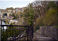
10
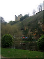
Knaresborough Castle from the banks of the River Nidd
Image: © Bill Henderson
Taken: 14 Apr 2009
0.02 miles