IMAGES TAKEN NEAR TO
Monarch Way, HG5 0TE
Introduction
This page details the photographs taken nearby to Monarch Way, HG5 0TE by members of the Geograph project.
The Geograph project started in 2005 with the aim of publishing, organising and preserving representative images for every square kilometre of Great Britain, Ireland and the Isle of Man.

There are currently over 7.5m images from over14,400 individuals and you can help contribute to the project by visiting https://www.geograph.org.uk
Image Map
Images are licensed for reuse under creativecommons.org/licenses/by-sa/2.0
Notes
- Clicking on the map will re-center to the selected point.
- The higher the marker number, the further away the image location is from the centre of the postcode.
Image Listing (24 Images Found)
Images are licensed for reuse under creativecommons.org/licenses/by-sa/2.0
Image
Details
Distance
1
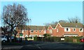
Knaresborough suburbia
A road on the Eastfield estate in Knaresborough, most of which dates from the 1980's.
Image: © Gordon Hatton
Taken: 20 Jan 2019
0.09 miles

3
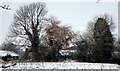
Manse Farm
Through the trees are the remaining upstanding buildings of Manse Farm in Hay-a-Park. There is a major building project by Linden Homes for 300 new homes across 8.5 ha of the old farms holdings, and it looks like from the plans that these farm buildings will be getting demolished in the near future, although it does look as though at least some of the mature trees will be staying.
It will certainly be interesting to take this view again in a few years time.
Image: © Matthew Hatton
Taken: 15 Jan 2021
0.11 miles
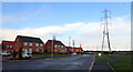
6

Pylon seen from Swallowtail Way, Knaresborough
Image: © habiloid
Taken: 8 Jan 2023
0.16 miles
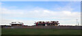
7

House-building seen from Holly Blue Close, Knaresborough
Image: © habiloid
Taken: 8 Jan 2023
0.16 miles
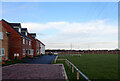
8
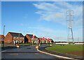
New properties with a view
Unfortunately the view is of giant pylons just across the new access road. There are three other housing developments on the fringe of Knaresborough which are very close to power lines. Not for me thank you. I believe current guidance allows development up to 50m from a power line, but that distance is considerably greater in some European countries.
Image: © Gordon Hatton
Taken: 27 Dec 2020
0.16 miles
9
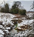
Bridge over Frogmire Dike
Taken from the A59 looking North into Hay-a-Park, one of the old deer parks associated with the lords of Knaresborough Castle in the Middle Ages.
The harras fencing is due to the housing development that is going into the fields in the area, whether or not this bridge will survive will be down to the planners, they have already blocked Three Oaks Lane.
Image: © Matthew Hatton
Taken: 10 Jan 2021
0.19 miles
10
House-building seen from Swallowtail Way, Knaresborough
Image: © habiloid
Taken: 8 Jan 2023
0.19 miles