IMAGES TAKEN NEAR TO
Boroughbridge Road, KNARESBOROUGH, HG5 0NG
Introduction
This page details the photographs taken nearby to Boroughbridge Road, HG5 0NG by members of the Geograph project.
The Geograph project started in 2005 with the aim of publishing, organising and preserving representative images for every square kilometre of Great Britain, Ireland and the Isle of Man.

There are currently over 7.5m images from over14,400 individuals and you can help contribute to the project by visiting https://www.geograph.org.uk
Image Map
Images are licensed for reuse under creativecommons.org/licenses/by-sa/2.0
Notes
- Clicking on the map will re-center to the selected point.
- The higher the marker number, the further away the image location is from the centre of the postcode.
Image Listing (606 Images Found)
Images are licensed for reuse under creativecommons.org/licenses/by-sa/2.0
Image
Details
Distance
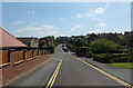
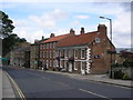
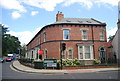
4
Boroughbridge Road - viewed from High Street
Image: © Betty Longbottom
Taken: 31 Aug 2009
0.04 miles
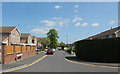
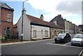
5
High Street, Knaresborough
The lower part of High Street, near the junction with Bond End
Image: © Dr Neil Clifton
Taken: 16 Jul 2009
0.05 miles
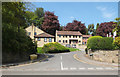
7
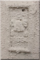
Flush Bracket Bench Mark, Former Royal Oak
Bench Mark Database: http://www.bench-marks.org.uk/bm21857
Image: © Mark Anderson
Taken: 18 Nov 2013
0.06 miles
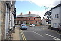
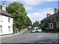
10
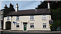
Former Royal Oak Inn
This property on the junction of High Street and Bond End in Knaresborough was the Royal Oak Inn until the 1990's. Now a private house on a busy corner.
Image: © Gordon Hatton
Taken: 31 Aug 2007
0.06 miles