IMAGES TAKEN NEAR TO
Garsdale Road, KNARESBOROUGH, HG5 0LU
Introduction
This page details the photographs taken nearby to Garsdale Road, HG5 0LU by members of the Geograph project.
The Geograph project started in 2005 with the aim of publishing, organising and preserving representative images for every square kilometre of Great Britain, Ireland and the Isle of Man.

There are currently over 7.5m images from over14,400 individuals and you can help contribute to the project by visiting https://www.geograph.org.uk
Image Map
Images are licensed for reuse under creativecommons.org/licenses/by-sa/2.0
Notes
- Clicking on the map will re-center to the selected point.
- The higher the marker number, the further away the image location is from the centre of the postcode.
Image Listing (24 Images Found)
Images are licensed for reuse under creativecommons.org/licenses/by-sa/2.0
Image
Details
Distance
1
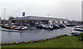
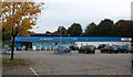
Lidl supermarket, York Road
The Lidl supermarket was opened in the autumn of 2008 and replaces a garden centre which formerly occupied the site on the east side of Knaresborough.
2021 update. Lidl has now moved a short distance to a newly constructed larger store on the former Co-op supermarket site off Chain Lane. The York Road site currently awaits redevelopment.
Image: © Gordon Hatton
Taken: 23 Jan 2009
0.12 miles
3
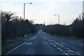
York Road, Knaresborough
The A59 York Road heading towards Knaresborough
Image: © Chris Heaton
Taken: 28 Dec 2015
0.14 miles
4
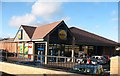
Co-op supermarket, Chain Lane
At the moment this is the only supermarket in Knaresborough.
March 2018 update: The supermarket has now been demolished and the site is being redeveloped, whilst at the entrance is a sign for Lidl supermarket, which gives the impression that the Lidl store will move from its current site on York road to this site where there is more room.
Image: © Gordon Hatton
Taken: 30 Oct 2008
0.16 miles
5
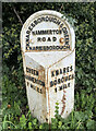
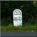
Old Milestone by the A59, York Road, Knaresborough parish
Metal plate attached to stone post by the A59, in parish of KNARESBOROUGH (HARROGATE District), York Road; almost opposite Manse Lane, near lamppost 226, on North side of road. WR iron casting, erected by the County Council in the 19th century.
Inscription reads:-
: GREEN / HAMMERTON / 7 MILES : : KNARESBOROUGH & GREEN / HAMMERTON / ROAD / KNARESBOROUGH : : KNARES / BOROUGH / 1 MILE :
North Yorkshire HER.
NY SMR Number: MNY36457 https://www.heritagegateway.org.uk/Gateway/Results_Single.aspx?uid=MNY36457&resourceID=1009
Milestone Society National ID: YN_KBGH01.
Image: © Tez Exley
Taken: 23 Sep 2023
0.17 miles
6
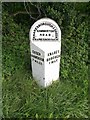
Old Milestone by the A59, York Road, Knaresborough parish
Metal plate attached to stone post by the A59, in parish of KNARESBOROUGH (HARROGATE District), York Road; almost opposite Manse Lane, near lamppost 226, on North side of road. WR iron casting, erected by the County Council in the 19th century.
Inscription reads:-
: GREEN / HAMMERTON / 7 MILES : : KNARESBOROUGH & GREEN / HAMMERTON / ROAD / KNARESBOROUGH : : KNARES / BOROUGH / 1 MILE :
North Yorkshire HER.
NY SMR Number: MNY36457 https://www.heritagegateway.org.uk/Gateway/Results_Single.aspx?uid=MNY36457&resourceID=1009
Milestone Society National ID: YN_KBGH01.
Image: © C Minto
Taken: 4 Oct 2003
0.17 miles
7
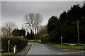
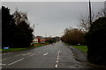
Manse Lane, Knaresborough
Manse Lane as seen from the A59, York Road
Image: © Chris Heaton
Taken: 28 Dec 2015
0.17 miles
8
Milestone on the A59, Knaresborough
The Knaresborough and Green Hammerton turnpike was established in 1752. The milestone is 19th century, cast iron attached to a stone pillar. See http://www.geograph.org.uk/photo/5538337 for location.
Image: © Alan Murray-Rust
Taken: 9 Sep 2017
0.17 miles
9
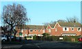
Knaresborough suburbia
A road on the Eastfield estate in Knaresborough, most of which dates from the 1980's.
Image: © Gordon Hatton
Taken: 20 Jan 2019
0.17 miles