IMAGES TAKEN NEAR TO
York Garth, KNARESBOROUGH, HG5 0AL
Introduction
This page details the photographs taken nearby to York Garth, HG5 0AL by members of the Geograph project.
The Geograph project started in 2005 with the aim of publishing, organising and preserving representative images for every square kilometre of Great Britain, Ireland and the Isle of Man.

There are currently over 7.5m images from over14,400 individuals and you can help contribute to the project by visiting https://www.geograph.org.uk
Image Map
Images are licensed for reuse under creativecommons.org/licenses/by-sa/2.0
Notes
- Clicking on the map will re-center to the selected point.
- The higher the marker number, the further away the image location is from the centre of the postcode.
Image Listing (114 Images Found)
Images are licensed for reuse under creativecommons.org/licenses/by-sa/2.0
Image
Details
Distance
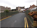
5
Pathway/Entrance - No5 York Road - Knaresborough
Pathway to house No5 York Road in Knaresborough.
There is an Ordnance Survey benchmark cut into the South East face of the building. The benchmark has been partially obscured by a careless routing of a waste water pipe
Associated photos can be seen in the links below
Image]
Image]
Image]
Image: © Tez Exley
Taken: 11 Sep 2023
0.05 miles
6
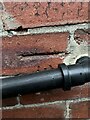
Cut Benchmark - No5 York Road - Knaresborough (1)
Datum line of cut Ordnance Survey benchmark on the North West face of No5 York Road in Knaresborough
The arrow cut has been obscured by the waste water pipe
Links to the arrow cut and associated photos can be seen below
Image]
Image]
Image]
Image: © Tez Exley
Taken: 11 Sep 2023
0.05 miles
7

Cut Benchmark - No5 York Road - Knaresborough (2)
Arrow cut Ordnance Survey benchmark on the North West face of No5 York Road in Knaresborough
The arrow cut has been obscured by the waste water pipe, the Datum line can be seen from above
Links to the Datum cut and associated photos can be seen below
Image]
Image]
Image]
Image: © Tez Exley
Taken: 11 Sep 2023
0.05 miles
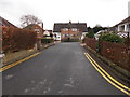
8
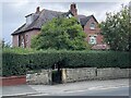
No5 York Road - Knaresborough
View of No5 York Road in Knaresborough. There is an Ordnance Survey benchmark cut into the South East face of the building. The benchmark has been partially obscured by a careless routing of a waste water pipe
Associated photos can be seen in the links below
Image]
Image]
Image]
Image: © Tez Exley
Taken: 11 Sep 2023
0.05 miles
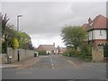
9
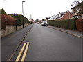
York Lane - viewed from Princess Avenue
Image: © Betty Longbottom
Taken: 30 Jan 2017
0.07 miles