IMAGES TAKEN NEAR TO
West Tanfield, RIPON, HG4 5LF
Introduction
This page details the photographs taken nearby to HG4 5LF by members of the Geograph project.
The Geograph project started in 2005 with the aim of publishing, organising and preserving representative images for every square kilometre of Great Britain, Ireland and the Isle of Man.

There are currently over 7.5m images from over14,400 individuals and you can help contribute to the project by visiting https://www.geograph.org.uk
Image Map
Images are licensed for reuse under creativecommons.org/licenses/by-sa/2.0
Notes
- Clicking on the map will re-center to the selected point.
- The higher the marker number, the further away the image location is from the centre of the postcode.
Image Listing (22 Images Found)
Images are licensed for reuse under creativecommons.org/licenses/by-sa/2.0
Image
Details
Distance
1
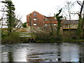
Tanfield Mill
Downstream from the village of West Tanfield on the banks of the River Ure.
Image: © David Rogers
Taken: 4 Apr 2009
0.01 miles
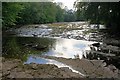
3
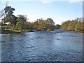
Rapids on the River Ure
Not very serious ones. A short way downstream from West Tanfield.
Image: © Oliver Dixon
Taken: 6 Nov 2006
0.04 miles
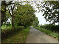
4
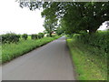
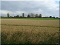
Hedge-lined minor road near to Tanfield Mill
Looking south-eastward.
Image: © Peter Wood
Taken: 15 Jun 2019
0.04 miles
6
River Ure
Low water levels during the summer.
Image: © Mick Garratt
Taken: 11 Jun 2011
0.07 miles
7
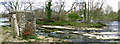
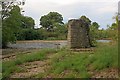
Sleningford Footbridge
Pillars are all that remain of a footbridge across the River Ure.
Image: © David Rogers
Taken: 4 Apr 2009
0.07 miles
9
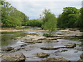
The Ure at Sleningford
Just upstream from Sleningford Mill where the river winds its way through and over areas of flat limestone. This is not the Carboniferous Limestone of the Dales, but part of the thin strip of Permian [Magnesian] Limestone that runs from Derbyshire to County Durham and which can be seen more locally at Knaresborough where the Nidd runs through a limestone and sandstone gorge.
Image: © Gordon Hatton
Taken: 13 May 2020
0.11 miles