IMAGES TAKEN NEAR TO
Main Street, RIPON, HG4 5JH
Introduction
This page details the photographs taken nearby to Main Street, HG4 5JH by members of the Geograph project.
The Geograph project started in 2005 with the aim of publishing, organising and preserving representative images for every square kilometre of Great Britain, Ireland and the Isle of Man.

There are currently over 7.5m images from over14,400 individuals and you can help contribute to the project by visiting https://www.geograph.org.uk
Image Map
Images are licensed for reuse under creativecommons.org/licenses/by-sa/2.0
Notes
- Clicking on the map will re-center to the selected point.
- The higher the marker number, the further away the image location is from the centre of the postcode.
Image Listing (229 Images Found)
Images are licensed for reuse under creativecommons.org/licenses/by-sa/2.0
Image
Details
Distance
1
House behind Marmion Tower
Viewed from window in Marmion Tower
Image: © Paul Buckingham
Taken: 26 Jun 2010
0.03 miles
2
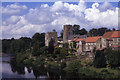
Marmion Tower and St Nicholas' Church, West Tanfield
Image: © Colin Park
Taken: 19 Jun 1990
0.03 miles
3
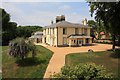
View from Marmion Tower
Looking down from the Marmion Tower toward the manor house.
Image: © Mark
Taken: 22 Sep 2013
0.03 miles
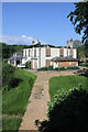
5
![West Tanfield houses [6]](https://s3.geograph.org.uk/geophotos/07/33/19/7331955_de05e112_120x120.jpg)
West Tanfield houses [6]
The Old Rectory, adjacent to both the Marmion Tower and the church. Badly damaged by fire on 31st May, 2022. Seen from the tower.
West Tanfield is a village in the Hambleton district of North Yorkshire, some 5½ miles northwest of Ripon. The village is sited on the north bank of the Rive Ure, astride the A6108 road from Ripon to Leyburn. The village name comes from the Anglo-Saxon 'tana feld', which mean "open land where young shoots grow" and is referred to in the Domesday Book. West Tanfield is home to the Marmion Tower, a 15th century gatehouse to the demolished manor house.
Image: © Michael Dibb
Taken: 24 Jun 2022
0.03 miles
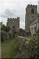
6
![Parish church [10]](https://s3.geograph.org.uk/geophotos/07/33/30/7333035_a30ce6b9_120x120.jpg)
Parish church [10]
Part of the churchyard.
The Anglican parish church of Saint Nicholas has some fabric from the early and late 13th centuries but was mostly rebuilt in the Perpendicular style in the15th century. It was heavily restored in 1859. Constructed of squared, coursed rubble stone with ashlar dressings under a Welsh slate roof. The church contains two 14th century alabaster effigies depicting Sir John and Lady Elizabeth Marmion. The effigies lie under a wrought-iron hearse. Ironwork of this date over a tomb is probably unique in this country. There are five more effigies against the north aisle wall. Listed, grade I, with details at: https://historicengland.org.uk/listing/the-list/list-entry/1150775
West Tanfield is a village in the Hambleton district of North Yorkshire, some 5½ miles northwest of Ripon. The village is sited on the north bank of the Rive Ure, astride the A6108 road from Ripon to Leyburn. The village name comes from the Anglo-Saxon 'tana feld', which mean "open land where young shoots grow" and is referred to in the Domesday Book. West Tanfield is home to the Marmion Tower, a 15th century gatehouse to the demolished manor house.
Image: © Michael Dibb
Taken: 24 Jun 2022
0.04 miles
7

The Old Rectory, West Tanfield
Seen from the Marmion Tower. The Old Rectory looks to have been gutted by a fire. It is rather annoying that one cannot take a sunlit photo of the tower in the afternoon because there is no public viewing point to the west.
Image: © Humphrey Bolton
Taken: 28 Oct 2022
0.04 miles
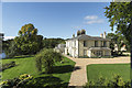
8
The Old Rectory, Main Street, West Tanfield
This house was built in 1804 by the then Rector Rev. William Baines. In 1947, the church decided it was no longer needed and the house was bought by Miss Mowbray. She paid 1s (5p) per annum to the estate for right of access through the Marmion Arch (I'm not clear if it also had access to Main Street at this time). In September/October 2008 development work comprised the demolition of existing outbuildings/extensions including a swimming pool, and the construction of a replacement range of buildings including garages, stores, a conservatory and a workshop. Stonework found during the works suggest it may be that the Old Rectory occupies the footprint of a major pre-existing building, with the outbuildings necessary to a medieval manorial complex located elsewhere on the site and so far undiscovered (Tanfield Castle?). A year ago, May 2022, a serious fire in the attic space resulted in collapse of the roof. Crews from Ripon, Masham, Bedale, Leyburn, Northallerton and Thirsk tackled the blaze. Firefighters were called to the old rectory for the second time in three days when smoke was coming from the roof space above a first floor bedroom caused by hotspots from the previous fire.
Image: © Jo and Steve Turner
Taken: 26 May 2023
0.04 miles
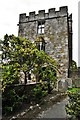
9
Marmion Tower
The church of St, Nicholas on the right and the remains of the Marmion Tower on the left. You can climb the spiral stairs to the viewing floor of the tower and get good views to the east and west.
Image: © Malcolm Neal
Taken: 1 Oct 2018
0.04 miles
10
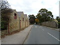
Main Street, West Tanfield
The A6108 through the village.
Image: © JThomas
Taken: 17 Oct 2020
0.04 miles