IMAGES TAKEN NEAR TO
Ellingstring, RIPON, HG4 4PW
Introduction
This page details the photographs taken nearby to HG4 4PW by members of the Geograph project.
The Geograph project started in 2005 with the aim of publishing, organising and preserving representative images for every square kilometre of Great Britain, Ireland and the Isle of Man.

There are currently over 7.5m images from over14,400 individuals and you can help contribute to the project by visiting https://www.geograph.org.uk
Image Map
Images are licensed for reuse under creativecommons.org/licenses/by-sa/2.0
Notes
- Clicking on the map will re-center to the selected point.
- The higher the marker number, the further away the image location is from the centre of the postcode.
Image Listing (14 Images Found)
Images are licensed for reuse under creativecommons.org/licenses/by-sa/2.0
Image
Details
Distance
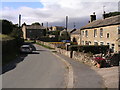
1
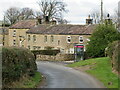
Ellingstring, farmhouse in village
This farmhouse is on the northern side of the road which runs through the village. On the right hand, lowest course of stone there is a benchmark which is slightly worn.
Image: © Mel Towler
Taken: 19 Jul 2021
0.01 miles
2
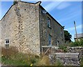
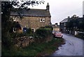
Ellingstring, farmhouse in village
A wider angle showing the gable end of the farmhouse which is sited on the northern side of the road which runs through the village. Note, the redundant milk churn stand on the roadside; this won't have been used for over 50 years. On the right hand corner stone, on the lowest course there is a benchmark which is slightly worn.
Image: © Mel Towler
Taken: 19 Jul 2021
0.01 miles
3
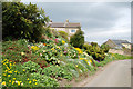
Roadside Flowers
Local residents have cultivated the roadside banking in Ellingstring. The Six Dales Trail long distance path passes through this village on its way to Middleham.
Image: © John Sparshatt
Taken: 23 Apr 2009
0.03 miles
4
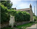
Cottages in Ellingstring
A tiny village sheltering in a hollow away from Pennine blasts of rain and wind. This row of sandstone cottages includes one that used to be the post office.
Image: © Gordon Hatton
Taken: 30 Jan 2021
0.06 miles
5
Lilac Cottage, Ellingstring YHA on 30 Sept 1979
1941-2003 was a 16-bed simple Youth Hostel.
Image: © John Lawson
Taken: 30 Sep 1979
0.13 miles
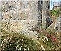
6
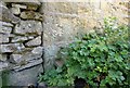
Ellingstring, Lilac Cottage
The cottage is on the western side of the road which runs through the village. The gable end of the cottage fronts onto the street and on the left corner stone of the lowest course there is a clear benchmark. It lies a few inches above ground level.
Image: © Mel Towler
Taken: 19 Jul 2021
0.14 miles
7
Ellingstring, Lilac Cottage
A wider showing the gable end of Lilac Cottage fronting onto the street which runs through the village. The cottage is on the western side of the road. On the left corner stone of the lowest course there is a clear benchmark. It lies a few inches above ground level.
Image: © Mel Towler
Taken: 19 Jul 2021
0.14 miles
9
Near Ellingstring
This footpath does not follow the route shown on the OS Explorer map.
Image: © T Eyre
Taken: 23 May 2023
0.16 miles