IMAGES TAKEN NEAR TO
Healey, RIPON, HG4 4LP
Introduction
This page details the photographs taken nearby to HG4 4LP by members of the Geograph project.
The Geograph project started in 2005 with the aim of publishing, organising and preserving representative images for every square kilometre of Great Britain, Ireland and the Isle of Man.

There are currently over 7.5m images from over14,400 individuals and you can help contribute to the project by visiting https://www.geograph.org.uk
Image Map
Images are licensed for reuse under creativecommons.org/licenses/by-sa/2.0
Notes
- Clicking on the map will re-center to the selected point.
- The higher the marker number, the further away the image location is from the centre of the postcode.
Image Listing (15 Images Found)
Images are licensed for reuse under creativecommons.org/licenses/by-sa/2.0
Image
Details
Distance
1
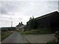
Crab House Farm
Stone built farmhouse with barns situated on the south side of the River Burn in hill country to the west of Masham.
Image: © Gordon Hatton
Taken: 3 Feb 2015
0.03 miles
3
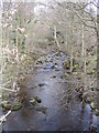
River Burn
Looking upstream from bridge
Image: © Angela Tuff
Taken: 12 Apr 2006
0.12 miles
4
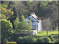
"The Bungalow"
Built by the Leeds Corporation Waterworks c.1911 as a two-storey mock-Tudor house for visiting engineers and for the Waterworks committee members for meals and overnight stays whilst construction of Leighton Reservoir was undertaken.
It is now a private house that stands out like an unusual eyesore in its rural setting.
Image: © Matthew Hatton
Taken: 14 May 2017
0.20 miles
5

Upstream along the River Burn
Looking along the river from Leighton Bridge.
Image: © DS Pugh
Taken: 15 Apr 2022
0.20 miles
6
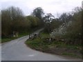
Country Road
By Leighton Bridge the road leads to the Leeds Pals Memorial at Breary Banks
Image: © Michael Graham
Taken: 1 May 2010
0.21 miles
7
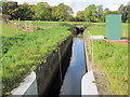
Man made water channel
Water channel, marked as "Catchwater" and "Drain" on maps, that possibly serves to take water from Spruce Gill Beck to Leighton Reservoir.
Image: © David Tyers
Taken: 19 Oct 2015
0.22 miles
8

Old Direction Sign - Signpost by Leighton Bridge, Healey parish
Located by Leighton Bridge on the northwest side of the junction of Trapping Hill and Breary Banks in Healey parish. 1 arm and broken annulus finial. See also https://www.geograph.org.uk/photo/7505197.
Milestone Society National ID: YN_SE1680
Image: © M Bardell
Taken: 1 Nov 2016
0.22 miles
9
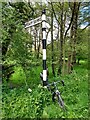
Direction Sign – Signpost near Leighton Bridge, Healey
Located by Leighton Bridge on the northwest side of the junction of Trapping Hill and Breary Banks in Healey parish. 1 arm and broken annulus finial. See also https://www.geograph.org.uk/photo/6061072.
Milestone Society National ID: YN_SE1680
Image: © H Jones
Taken: 1 Jun 2023
0.22 miles