IMAGES TAKEN NEAR TO
Masham, RIPON, HG4 4LD
Introduction
This page details the photographs taken nearby to HG4 4LD by members of the Geograph project.
The Geograph project started in 2005 with the aim of publishing, organising and preserving representative images for every square kilometre of Great Britain, Ireland and the Isle of Man.

There are currently over 7.5m images from over14,400 individuals and you can help contribute to the project by visiting https://www.geograph.org.uk
Image Map
Images are licensed for reuse under creativecommons.org/licenses/by-sa/2.0
Notes
- Clicking on the map will re-center to the selected point.
- The higher the marker number, the further away the image location is from the centre of the postcode.
Image Listing (6 Images Found)
Images are licensed for reuse under creativecommons.org/licenses/by-sa/2.0
Image
Details
Distance
1
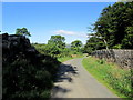
Lane by the Perimeter of Swinton Park
The park is surrounded by a very long perimeter wall, part of which is followed by this lane
Image: © Chris Heaton
Taken: 5 Sep 2012
0.06 miles
2
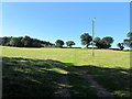
Pasture to the South of Swinton Park
As seen from the lane outside the perimeter of Swinton Park
Image: © Chris Heaton
Taken: 5 Sep 2012
0.08 miles
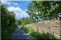
3
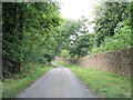
Following the wall
A narrow road follows the boundary wall of the Swinton Park estate from Warthermarske.
Image: © Gordon Hatton
Taken: 21 Aug 2018
0.09 miles
4
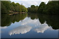
Top Lake
Top Lake at Swinton Park is still referred to as Lake Superior on the 1:25,000 scale OS map.
Image: © David Rogers
Taken: 18 May 2008
0.17 miles
5
Warthermarske, boundary wall
The wall on the east side of the road is a boundary wall to Storth Wood. There is a benchmark cut into the wall at this location.
Image: © Mel Towler
Taken: 25 Jun 2022
0.21 miles
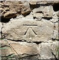
6
Warthermarske, boundary wall
The wall on the east side of the road is a boundary wall to Storth Wood, Swinton Park Estate. There is a benchmark cut into the wall at this location.
Image: © Mel Towler
Taken: 25 Jun 2022
0.21 miles