IMAGES TAKEN NEAR TO
Thornton Watlass, RIPON, HG4 4AQ
Introduction
This page details the photographs taken nearby to HG4 4AQ by members of the Geograph project.
The Geograph project started in 2005 with the aim of publishing, organising and preserving representative images for every square kilometre of Great Britain, Ireland and the Isle of Man.

There are currently over 7.5m images from over14,400 individuals and you can help contribute to the project by visiting https://www.geograph.org.uk
Image Map
Images are licensed for reuse under creativecommons.org/licenses/by-sa/2.0
Notes
- Clicking on the map will re-center to the selected point.
- The higher the marker number, the further away the image location is from the centre of the postcode.
Image Listing (6 Images Found)
Images are licensed for reuse under creativecommons.org/licenses/by-sa/2.0
Image
Details
Distance
1
Countryside seen from the Thornton Watlass/Thirn Road
This looks over countryside seen south from the road between Thirn and Thornton Watlass on the eastern valley slopes of Lower Wensleydale.
Image: © Chris Heaton
Taken: 29 Aug 2015
0.19 miles
3
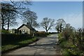
Road near Hermitage Lodge
Looking along a road leading west from Thornton Watlass.
Image: © DS Pugh
Taken: 31 Mar 2021
0.20 miles
5
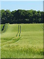
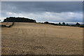
Lines through the crops
Field of Barley near Thornton Watlass ripening in the late May sunshine.
Image: © Gordon Hatton
Taken: 30 May 2020
0.24 miles
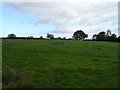
6
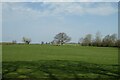
Farmland west of Thornton Watlass
Looking north of the road leading west from Thornton Watlass.
Image: © DS Pugh
Taken: 31 Mar 2021
0.24 miles