IMAGES TAKEN NEAR TO
Bridge Cottages, RIPON, HG4 3TD
Introduction
This page details the photographs taken nearby to Bridge Cottages, HG4 3TD by members of the Geograph project.
The Geograph project started in 2005 with the aim of publishing, organising and preserving representative images for every square kilometre of Great Britain, Ireland and the Isle of Man.

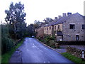
There are currently over 7.5m images from over14,400 individuals and you can help contribute to the project by visiting https://www.geograph.org.uk
Image Map
Images are licensed for reuse under creativecommons.org/licenses/by-sa/2.0
Notes
- Clicking on the map will re-center to the selected point.
- The higher the marker number, the further away the image location is from the centre of the postcode.
Image Listing (15 Images Found)
Images are licensed for reuse under creativecommons.org/licenses/by-sa/2.0
Image
Details
Distance
1
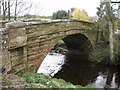
Bridge over the Laver
A sandstone bridge carrying a road over the River Laver in Laverton. Two inscribed stones show that the bridge was rebuilt in 1923. The Laver is the main tributary of the Skell, the two small rivers uniting on the edge of Ripon before joining the Ure.
Image: © Gordon Hatton
Taken: 14 Apr 2008
0.02 miles
2
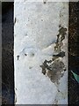
Laverton bridge
An aerial view of the eastern parapet showing the benchmark cut into the top stone, and now coated in lichen. See https://www.geograph.org.uk/photo/7118857
Image: © Mel Towler
Taken: 9 Feb 2022
0.02 miles
3
Laverton bridge
The eastern parapet of Laverton bridge showing the benchmark cut into the top stone in the centre of the bridge, and now coated in lichen.
Image: © Mel Towler
Taken: 9 Feb 2022
0.02 miles
4
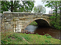
Bridge, Laverton
A single segmental arch carrying the road over the River Laver. It was rebuilt in 1923 (Image]).
Image: © Stephen Richards
Taken: 15 May 2013
0.03 miles
5
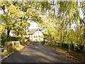
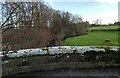
Road bridge over the River Laver into Laverton
Property this side is in Low Green, the former village chapel is directly ahead
Image: © Martin Dawes
Taken: 11 Nov 2016
0.03 miles
6
Laverton
Hamlet on the River Laver, about half a mile south of Kirkby Malzeard
Image: © Chris Heaton
Taken: 8 Jan 2006
0.04 miles
7
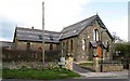
Former chapel in Laverton
This was formerly the Methodist chapel, built in 1895 and closed as a place of worship in January 2002. It has since been converted into a private house.
Image: © Gordon Hatton
Taken: 14 Apr 2008
0.06 miles
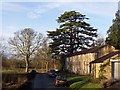
8
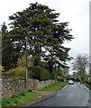
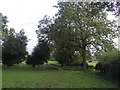
Conifer, Laverton
Possibly a type of cedar.
Image: © Stephen Richards
Taken: 15 May 2013
0.09 miles
10
Public Footpath
We walked this footpath initially from west to east over several very difficult stiles and nearly got to our goal of the minor road at the other end, only to be greeted in the last field by a herd of cows..... jealously guarded by one big bull. Nevertheless, we about turned and came back the way we'd come! I bet this public footpath doesn't get used to its full potential very often!
Image: © Andy Beecroft
Taken: 22 Oct 2006
0.15 miles