IMAGES TAKEN NEAR TO
Galphay Road, RIPON, HG4 3SS
Introduction
This page details the photographs taken nearby to Galphay Road, HG4 3SS by members of the Geograph project.
The Geograph project started in 2005 with the aim of publishing, organising and preserving representative images for every square kilometre of Great Britain, Ireland and the Isle of Man.

There are currently over 7.5m images from over14,400 individuals and you can help contribute to the project by visiting https://www.geograph.org.uk
Image Map (Loading...)


Getting Data...Please wait
Leaflet Map data © OpenStreetMap
Images are licensed for reuse under creativecommons.org/licenses/by-sa/2.0
Notes
- Clicking on the map will re-center to the selected point.
- The higher the marker number, the further away the image location is from the centre of the postcode.
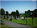
Image Listing (6 Images Found)
Images are licensed for reuse under creativecommons.org/licenses/by-sa/2.0
Image
Details
Distance

5
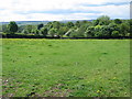
View over Laverton and Dallowgill
View from footpath towards Laverton and Dallowgill. An excellent walk through Meadows surrounding Kirkby Malzeard and Laverton. Dallowgill and the hills in the distance are all grouse moors.
Image: © roger nightingale
Taken: 30 May 2010
0.23 miles
6

Market Cross, Kirkby Malzeard
Situated at the eastern edge of the village, near the church. Inscription states that a market charter was granted to John de Mowbray by Edward I (Longshanks) in 1307
Image: © Chris Heaton
Taken: 13 Jun 2006
0.24 miles